Overview of the monitoring techniques
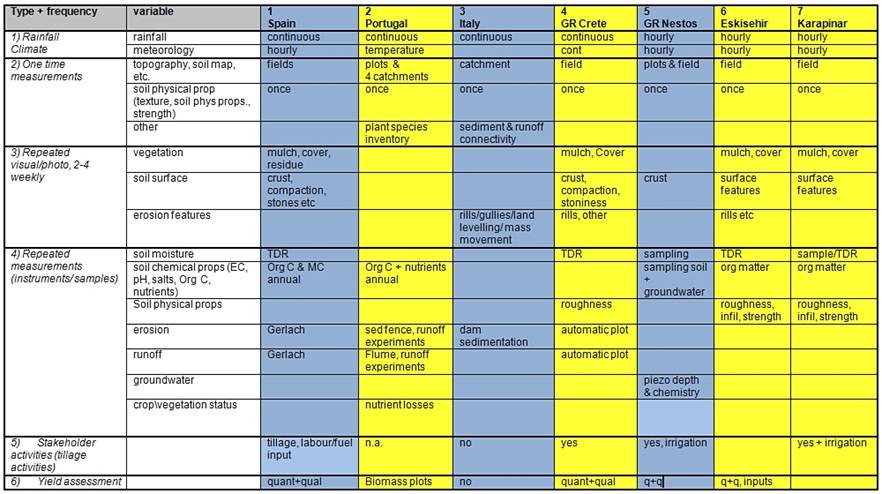
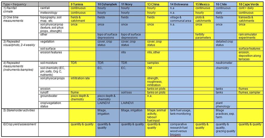
- Rainfall & meteo. One of the most important aspect is a detailed recording of the rainfall. With that and the knowledge of long term climatic seasonal variations, it can be judged if the years under observation are in anyway special (dry, wet) or average. This may be of importance to judge the results of the monitoring and effectiveness of the technologies. For example, minimum tillage may not have the desired or expected soil moisture improvement when the season is very dry, even in comparison with a non treated field. All sites have both rainfall data (most continuous, i.e. tipping bucket high resolution data) and meteo data, usually hourly or daily. The meteo stations are sometimes several kilometres from the trials, the rainfall measurements are always done on the trial fields themselves.
- One time measurements. These are mostly landscape data of the trial location (DEM, slope etc) and soil physical data. The latter contains texture, bulk density, porosity and infiltration variables (mostly Ksat). These are taken with samples or with infiltration and rainfall simulator experiments. Of the soil chemical data, some fertility measurements are done but mostly organic matter is sampled. Also variables such as stoniness and soil depth are estimated.
- Regular observations. These are visual observation and digital photographs, either of the plots or of sample frames of e.g. 1 m2. These are used to monitor soil surface structure changes, such as crusting and compaction. Mulch is also monitored with photographs were selected as a technology. Vegetation/crop changes are recorded by observation, mostly crop cover and height, and general plant health. Chile observes crop phenology in more detail. Water erosion is observed visually by tracking rills, gullies behaviour and deposition.
- Regular measurements and sampling. On most sites the soil moisture content is monitored, either with TDRs or by sampling. Furthermore groundwater levels and groundwater chemistry is monitored in Greece (Nestos basin) and Russia (Dzhanybek and Novy) because of the irrigation related problems there. On a number of sites, runoff and sediment losses are measured using flumes and recorders, or using sample tanks. These are directly installed at the plot/field level, or are installed at the catchment level in which the plots are situated (while the erosion at the plot level is visually judged). A special case it Botswana where fuelwood use is compared to biogass efficiency, and amount and quality of cow dung is monitored.
- Stakeholder activities. These include all tillage activities and moments the stakeholders interfere with the fields. Also labour and fuel consumption are registered where applicable. The stakeholders are asked regularly for their opinion and evaluation of the implemented technologies. Where applicable, irrigation amounts are registered.
- Yield assessment. Yield quality and quantity is registered each growing season. In some sites quality and quantity of grazing is monitored.
Tables 3a and 3b provide an overview of monitoring activities on the sites, divided into 5 categories:

Table 3a: Overview of the monitoring activities on the first 7 sites.

Table 3b: Overview of the monitoring activities on the second 8 sites.