Conservation measures and experimental setup
In total three experimental fields will be set-up (A, B, C; Figure 1). Figures 2-4 illustrate the experimental layout in each of these three fields. Figure 2 illustrates the experiments in an Almond field where reduced tillage and green cover will be applied. For comparison a control plot will be monitored in this field resulting in a total of 3 measures. All 3 measures will be applied in a block of 3*4 almond trees. At the lower end of this block 3 Gerlach erosion plots will be installed according to the design explained in Figure 5. In addition, ephemeral gully development will be monitored at the field outlet by repeated (once a year and after each event) measurements with a laser scanning equipment.
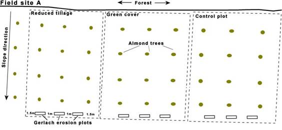
Figure 2: Experimental design of experimental plots in filed site A. In this field site two conservation measures are applied: 1) reduced tillage, 2) green cover. The third plot is a control plot with conventional farming operation.
An overview of the agricultural activities under each of the conservation measures in the different plots is given in Table 1. Reduced tillage is applied in Almond fields to maintain soil structure, increase organic matter content and reduce erosion. Almond fields in the study area are normally ploughed 3-5 times per year. Under reduced tillage, ploughing will be reduced to twice a year: in autumn before autumn rainfall (September) and repeated in end of the winter (February-March) before spring rainfall. When necessary, weed control will be obtained by mowing the weeds after rainfall events.
An alternative way of mulching is by seeding cereals below the trees as a green cover. Therefore, a mixture of cereals and Vicia sativa will be seeded under the Almond trees in October. Beside a surface cover the Vicia sativa is a leguminous species which has a Nitrogen fixating effect and serves as a green manure often used under ecological agriculture. In early spring (when the leaves are still green) the green cover will be ploughed and mixed with the upper soil layer. The moment of ploughing is crucial to maximise the fertilizer effect and prevent competition for water resources.
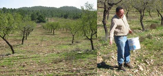
Photo 1: Slope section of Field site A just before ploughing (left) and seeding of the green manure (right) in early November 2008 (Photos by Joris de Vente).
Figure 3 illustrates the experimental set-up in an Almond field with a water harvesting structure (Field site B). A 'Boquera' is a traditional water harvesting structure. It is formed by creating an earthen-wall in the centre or lateral part of an existing rambla, parallel to the river banks. During water flow in the rambla this wall leads the flood water from the rambla to a small channel (Acequia) towards a cascading system of cultivated fields which will be flooded. In order to be able to assess the amount of water inflow from the Boquera, a pressure measuring device will placed just before entering the field to measure water height and inflow. Three terraces will be monitored (see Figure 3). In the lower terrace additional water enters during rainfall events from the lateral channel by (partially) closing the door in the channel and opening the door towards the Almond field.
In the middle terrace no additional water inflow will occur. Instead, straw mulch will be applied to provide a permanent surface cover that reduces evaporation losses and limits the growth of weeds. This makes that less ploughing is needed under Almond trees that are normally ploughed 3-5 times per year if no mulch cover is present. After ploughing, mulch will be applied in autumn and if needed repeated in spring (March) to maintain soil humidity of spring rainfall. The mulch will be applied over a wide area, not deep (max 3-5 cm). In addition to the straw, pruning residues are chopped and spread around the tree stem in September - October. An overview of the agricultural activities under each of the conservation measures in the different plots is given in Table 1.
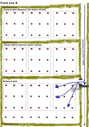
Figure 3: Experimental design of measurements in an Almond field with a water harvesting structure (Boquera-Acequia). By closing the main channel and opening the door to the lower terrace, the latter receives additional water from the channel while the upper two terraces do not.
The upper terraces without additional water inflow will serve as a control plot. In this way the effect of additional water from a Boquera, and the effect of reduced evaporation losses through mulch cover on soil parameters and crop yield will be monitored independently. In each of the 3 terraces measurements will be performed in 3 nested blocks of 3*3 Almond trees. Erosion will not be measured in these terraces since the terraces are nearly flat.
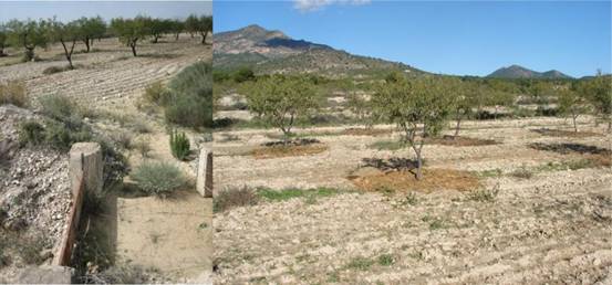
Photo 2: Field site B with the inlet of the Boquera to the Almond field (left) and the straw mulch below the Almond trees in the adjacent terrace (right) (Photos by Joris de Vente).
Figure 4 shows the experimental design in a cereal field (Field site C). In this field a section of approximately 20*7 meters will be ploughed following conventional ploughing scheme with a mouldboard plough as a control plot. In the other section of the same size reduced tillage with a disc-plough will be used. At the lower end of each section 3 Gerlach erosion plots will be installed following the design in Figure 5.
The reduced tillage section is ploughed once every two years with a disc- or a chisel-plough. The disc-plough is used in case of a dense annual vegetation cover and crop residue; otherwise the chisel plough will be used. Cereals are cropped in a rotational system with fallow land as follows: cereals are seeded in autumn (October) and harvested in June, followed by a fallow period of a year where crop residues are left on the field throughout autumn and the winter period, as such providing an increased surface cover and protection against soil erosion. Tillage is performed on fallow land in spring time (April-May) that prepares the land for seeding in autumn (October). Tillage is performed parallel to the contour lines. No herbicides are applied. In the control plot with conventional tillage the same crop scheme is used, only the plot is ploughed more frequent with a mouldboard plough. An overview of the ploughing activities is given in Table 1.
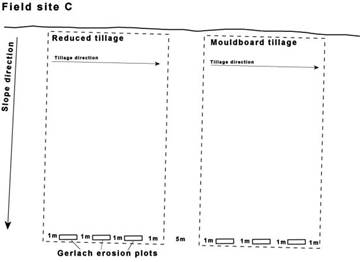
Figure 4: Experimental design in a cereal field (Field site C) with reduced tillage (left) and conventional tillage (right) operation.
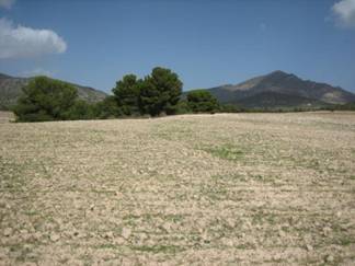
Photo 3: View on slope segment of field site C before seeding of cereals in October 2008 (Photo by Joris de Vente).
As is explained in the previous paragraphs and figures each conservation measure will be performed with 3 replicas as embedded open 'plots' within 1 field. However, in order control the source area of each plot, small earthen elevations (~20cm) will be constructed between each plot to prevent runoff from one plot into the other. It was decided not to close the plots with construction material since this will complicate tractor movement in the fields. The fields are located in one soil type. Also 1 control site per conservation measures will be monitored in the same field on the same soil type and slope angle.