Bio-physical description
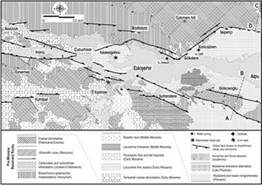
The Eskişehir region is situated in the western part of the central Anatolian Plateau. This plateau generally lies at 900-1000 m above sea-level and is dissected by some volcanic edifices, and depressions and uplifts of tectonic origin. The Eskişehir study site is located in the northern margin and partially at the floor of such a through-going depression, called the Eskişehir Basin (Figure 3). The Porsuk River and Sarısu Creek drain the basin floor as well as the surrounding plateau to feed the larger Sakarya River in the east. A variety of rocks crop out in vicinity of the study site area. Metamorphic rocks with mappable ultramafic and carbonate subunits are found at high altitude and steep slopes. Consolidated terrigenous conglomerates and sandstones particularly are widespread in the basin margin. The younger loose fluvial terraces and Recent alluvial deposits mostly distributed over graben floor (Figure 3). Marble lenses within the metamorphic rocks in vicinity of Keskin and Uludere villages in the study site are actually mined in spite of resulting environmental problems.
Figure 3: Geology of the Eskisehir basin

The study site area is characterized by a dry continental climate with an annual precipitation of 380 mm. Rainfall mostly occurs in spring as showers, while snow makes up a significant part (40%) of total precipitation (Figure 4). Winds dominantly blow in east-west direction and may reach the tempest limits in 21 days a year. Air temperatures generally are below 0° during winter and may exceed 40° in summer days. Soil temperature temporally range between -0.8-25.5 0C 5-10 cm below the surface.
Soils of the study site are dominantly thin lithosols developed on schists while a significant part of the steep slopes are bare. Only limited parts of the study site comprise well developed and thicker probably older pinkish soils. Valley bottoms and particularly the flat graben floor is covered by a very thick (>2 m) grey coloured productive soil.
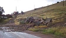
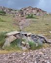
Figure 4: Erosion and debris flow after a heavy rainfall in vicinity of the study area


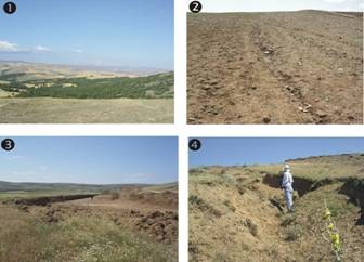
Figure 5: Various aspects of land degradation in Eskişehir study site.
1-Cropland intrusion through degraded oak forest; 2- Wrong tillage direction and resulting gully erosion;
3- Soil trade as an industrial material (Uludere village); 4- Deep active gully erosion in a pasture land.

| Coryllus calurna | 32 | Asyneuma rigidum | ++ | Tanacetum armenum | ++ |
| Quercus petraea | 22 | Euphorbia macroclada | ++ | Astragalus angustifolius | ++ |
| Carataegus monogyna | ++ | Dianthus cibraricus | ++ | Plantago sp. | ++ |
| Quercus cerris | ++ | Jurinea pontica | ++ | Genista sessilifolia | ++ |
| Koeleria cristata | ++ | Allium sp. | ++ | Pyrus elaeagnifolia | ++ |
| Arenaria sp. | ++ | Minuartia sp. | ++ | Hypericum perforatum | ++ |
| Prunus sp. | ++ | Juniperus oxycedrus | ++ | Torilis arvensis | ++ |
From the viewpoint of land use, almost half of the Eskişehir region is suitable for agricultural activities while a fourth is occupied by meadows and the remainder by forests. In the study site area, the most common land use type is unirrigated cultivation (mostly cereals) followed by meadows, irrigated cultivation (sugar beet and sunflower) and very rare fruit vegetation and man-made forests (mainly pine and oak trees). In the pasturelands, vegetation cover consists of steppe vegetation and degraded forest remnants as dominantly result of anthropogenic effects. Although herbaceous cover is generally high (70%) and relatively rich herb species occurs in the study site (Table 1), heavy grazing in vicinity of villages still causes intense degradation due to water erosion. A few monumental juniper trees of probably many hundred years old witness once occurrence of widespread mountain forests in the region. A significant amount of fish production also is made from several dams in the region. The Keskin dam in the study site serves only amateur fishery activities. According to national agriculture statistics, the Eskişehir area is the 4th in the country with respect to agricultural production per person. The study site is also under stress of urbanization related to Eskişehir city (population of 500.000) with many industrial complexes in the sectors of sugar, ceramics, cement, flavour production as well as plane motor and locomotive factories. These agro-economic activities make the area 14th most developed province (total 81) with respect to added value in manufacture sector.
Most of the farmers in the study site use their very fragmented own lands. Land hiring may be particularly significant due to insufficient agricultural income and high costs in certain stagnant periods.
Although groundwater resources are rich they are confined within the alluvium of low-lying Eskişehir Plain. But state authorities carefully allocate the irrigation licenses with the thought of a future drought. For the steep slopes of the northern study site, groundwater resources are almost lacking or probably confined in the small karst aquifers. Running water is particularly scarce or highly contaminated. Flow and sprinkler irrigation are the most common while drip irrigation is encouraged by state institutions. Agriculture in most of the area relies on rainfall, for this reason fallow is a common obligatory practice. Villagers use scarce spring waters that are generally not enough for their daily domestic needs. The propriety of the Keskin dam in the area is under discussion. Municipality authorities want to use dam water for domestic use in Eskişehir city while State Water Affairs inclines towards foremost agricultural usage of this dam.
A very limited part of the study site is covered by weak remnant oak forests. Some older (>50 years) and particularly more recent reforestation initiatives are undertaken by state organizations and some NGO here and there, and especially in the northern steep meadows of the study site.
In the present situation, land use practices aim only to survive; in other words no special care was paid to protect soil and other resources since they hardly provide income to live due to increasingly harder economic bottlenecks. For this main reason, biodiversity is rapidly vanishing in meadows, topsoils are disappearing and soil fertility is declining in croplands. The actual land use practices are regarded uneconomic mostly due to low market prices and very high costs.
A comprehensive land degradation assessment has not been realized up to now in the Eskişehir area neither in the study site, though some studies have aimed for determination of water and wind erosion as well as for remediation of soil and the irrigation systems in the Eskişehir Plain.