General information
The 'secano interior' (interior dryland) in Chile extends from the V to the VIII Administrative Regions (32° - 37 °S). According to ODEPA (2002) the area has an extension of 1.671.900 ha distributed among five Regions (Table 1). The interior dryland in the VII and VIII Region, the study site for DESIRE, represent 55% of the total area, 909,724 hectares.
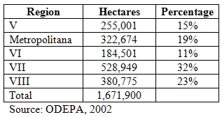
Table 1: Area occupied by the interior dryland of Chile distributed by Administrative Region.
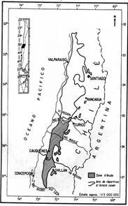
Figure 1 and 2, shows the location of the area.
 |
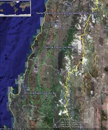 |
| Figure 1: Map of interior dryland in Chile and study site (Cauquenes) for DESIRE. | Figure 2: Location of the interior dryland in the study site area of Chile. |
From the almost 1 million ha of the study site area, 77% is utilized for production. Natural pasture and forestry plantation, mainly eucalyptus (Eucaliptus globolus) and Monterey pine (Pinus radiata), are the most relevant land uses (583,594 ha), followed by annual crops (mainly wheat and pulses) and vineyards (Table 2). Although, the data for this analysis were obtained from CENSO (1997), we believe that the ranking of each economic activity should be similar according. However, we expect an important increase of forestry plantation on the last 10 years, replacing areas with natural pasture.
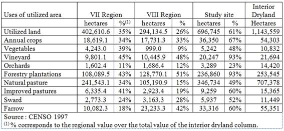
Table 2: Distribution of the utilized area in the interior dry land of the VII and VIII Region.
The area is characterized by the co-existence of a large number of small holders and subsistence agriculture, and large scale farms dedicated almost exclusively to forestry plantations (Table 3).
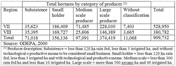
Table 3: Dry land area in the VII and VIII Regions distributed by category of producer
The average farm sizes (in ha) by category of producer is shown in Table 4.

Table 4: Average farm size by category of producer in the interior dryland of the VII and VIII Regions.