Tourism indicators
The Mediterranean coastline is roughly 46,000 km long and is almost equally divided into rocky and sedimentary coasts. Over the last three decades the Mediterranean countries experienced a tremendous growth of population increase. Population pressure is exacerbated by tourism. Tourism industry plays an important role in the Mediterranean economy and it is expected to increase in the near future. However, tourism has created a number of environmental problems ranging from loss of agriculture lands, water pollution, coastal erosion, increasing water consumption, decreasing recharge of aquifers, flooding of lowland, soil salinization, etc. The increasing tourism exerts a significant impact on the land-use patterns and the allocation of water resources. The most immediate changes in land-use is: (a) the shift in crop production to meet the high tourist requirements, (b) the replacing several of the traditional crops, and (c) the abandonment of lands of low quality. The high demands for water consumption or other economic activities have increased the price of water and forcing the cost of agricultural production, while in many cases, water of low quality is used for irrigation causing soil salinization problems. Coastlines are being sealed over by harbours and marinas, roads, houses, other facilities to accommodate the expansion of tourist industry, removing fertile soils from production and the interrupting functions with the environment.
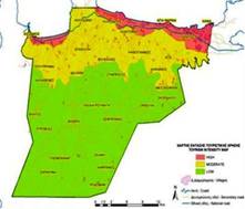
Some of the study sites located in the inland; such as Djanybek-Russia, Guadalentin Basin Murcia-Spain, Eskisehir-Turkey; do not have significant effects from tourism, but others such as Santiago Island-Cape Verde, Zeuss Koutine-Tunisia, Konya Karapinar plain-Turkey, Crete-Greece are subjected to high tourism pressure (Fig. 93). The following two indicators have been selected for assessing the effect of tourism on land degradation and desertification: (a) tourism intensity, and (b) tourism change.

Fig. 93. Map of region of Chania-Crete showing areas subjected to high (red color), moderate (yellow color) and low (green color) tourism pressure
Table 13. Number of field sites in which indicators related to tourism was recorded in the filled questionnaires
| site no | Study site |
Tourism intensity (Number of overnight stays / 10 km2 area) |
Tourism change (Number of overnight stays in a specific destination over one year / average overnight stays in the last 10 years) |
| 1 | Rendina Basin, Basilicata, Italy | - | - |
| 2 | Loess Plateau, China | - | - |
| 3 | Secano Interior, Chile | 28 | - |
| 4 | Nestos Basin, Maggana, Greece | 30 | - |
| 5 | Gois, Portugal | 30 | 30 |
| 6 | Mação, Portugal | 31 | 31 |
| 7 | Boteti Area, Botswana | 39 | 25 |
| 8 | Eskisehir, Turkey | 70 | - |
| 9 | Konya, Karapinar plain, Turkey | 74 | - |
| 10 | Santiago Island, Cape Verde | 103 | - |
| 11 | Cointzio Watershed, Mexico | 87 | 20 |
| 12 | Mamora/Sehoul, Morocco | 120 | - |
| 13 | Zeuss-Koutine, Tunisia | 120 | - |
| 14 | Guadalentin Basin, Murcia, Spain | 121 | - |
| 15 | Djanybek, Russia | 98 | 29 |
| 16 | Novij, Saratov, Russia | 122 | 62 |
| 17 | Crete, Greece | 269 | - |
| TOTAL | 1342 | 197 |