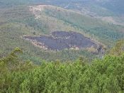
General photos of the Guadalentín basin, illustrating a number of aspects of desertification.
|
Tractor ploughing |
Location of Guadalentín |
Occurrence of gully erosion |
Guadalentin drainage basin, Spain |
|
Torrealvilla catchment, Spain |
Rainfall characteristics |
Potential evapotranspiration |
Aridity index |
|
CORINE 2000 land use map |
Aquifers |
Municipalities |
Overview of study areas |
|
Erosion assessments |
RUSLE soil loss estimates |
PESERA soil erosion assessments |
Reservoirs |
|
Potential for bank erosion |
Valdeinfierno reservoir #2 |
Potential for mass movements |
Puentes reservoir |
|
Levelled land |
Young almonds |
Almonds & steep slopes |
Pig farm |
|
Pig |
Ploughing |
Reforestation 1 |
Reforestation 2 |
|
Stone cover |
Gully development |
Bank protection |
Upper Guadalentín |
|
Check dam 1 |
Check dam 2 |
Levelled land 1 |
Sheep & lettuces |
|
Sheep & cabbages |
Irrigated agriculture |
Abandoned land |
Terraced almonds |
|
Marginal & irrigated land |
Levelled land 2 |
Map of Alagueces site |
Salt water |
|
Location of Guadalentin basin |
Salt crust |
Map of Torrealvilla within Guadalentin basin |
Map of Torrealvilla site |
|
Map of Transect A |
Cereal fields 1 |
Cereals & shrublands |
Map of Transect B |

Acknowledgement
The DESIRE project was
|
DESIRE brought together the expertise of
26 international research institutes
and non-governmental organisations.
This website does not necessarily
represent the opinion of the
European Commission. The European
Commission is not responsible for
any use that might be made of the
information contained herein. 


