- Description
-
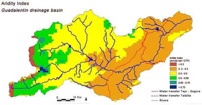
Aridity Index in the Guadalentín defined as the ratio between mean annual rainfall and potential evapotranspiration (UNESCO, 1979), in the period 1971-2000. The station data used for this map were provided by the Instituto Nacional de Meteorología.

Acknowledgement
The DESIRE project was
|
DESIRE brought together the expertise of
26 international research institutes
and non-governmental organisations.
This website does not necessarily
represent the opinion of the
European Commission. The European
Commission is not responsible for
any use that might be made of the
information contained herein. 

