Geology
The Geological profile shows a superficial water table in the Pliocene and the old alluvial terraces and a deeper water table in the Miocene mollasse, on top of the Paleozo´c basement

Figure 4: Profile of the Sehoul commune from the Mamora in the north

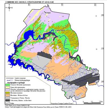
Figure 5: Geological map of the Sehoul commune
The Pliocene and Pleistocene calcarenites have been deeply weathered and furnish a thick red soil in which processes of leaching have occurred that produced a sandy superficial horizon, locally eroded, over a Bt horizon. This horizon has been locally removed by the wind during the dry period 22000 - 18000 years BP, before it stabilized again in the Holocene optimum, during which an organic layer was formed on top of this ancient dune.