Vegetation
The study area is characterized by a high diversity of vegetation types. They are linked to several ecological groups whose major part is soil groups (Ouled Belgacem et al., 2003) (Associations of Anarrhinum brevifolium and Zygophyllum album, of Artemisia herba-alba and Hammada scoparia...), but also influenced by human pressure (association of Pituranthos tortuosus and Haplophyllum vermiculare, facies of Pituranthos tortuosus and Artemisia campestris). This could be explained by the important role of soil and man in the determination of the plant cover in these arid regions of Tunisia. This analysis allowed us not only to locate the main vegetation types which have been determined earlier but also identify new degraded facies of Helianthemum lippii var. intricatum of the Anarrhinum brevifolium and Zygophyllum album association.
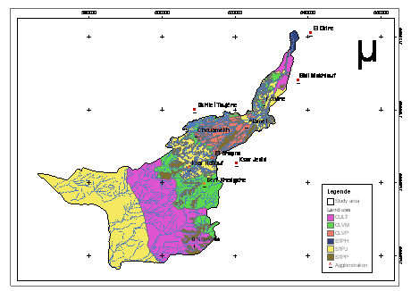
The determination of these different vegetation types and the spacialization of the field data meaning the GIS permitted the establishment of the vegetation map of 2001 (Ouled Belgacem, 2003). A high diversity of vegetation types was found due to biotic factors (soil water availability, physico-chemical characteristics of soils) as well as to abiotic factors (topography, human activities). According to the topsequence, we can distinguish relics of the Juniperus phoenicea and Rosmarinus officinalis evergreen garrigue at higher calcareous mountains followed by the Stipa tenacissima steppe which dominates the calcareous crust mountains. When degraded, this steppe has been replaced by the Artemisia herba-alba and Hammada scoparia steppe with its Gymnocarpos decander facies. In the piedmont with gypseous crusts, the Anarrhinum brevifolium and Zygophyllum album is mostly degraded and very often replaced the Astragalus armatus, Atractylis serratuloides or Lygeum spartum steppe. The low-lands are very often covered by steppes of Ziziphus lotus, but in "stream beds" the Artemisia campestris and Thymus capitatus steppe often dominated. The sandy valleys to the south-west of the study area are mainly dominated by a very degraded Rhanterium suaveolens steppe which has been generally replaced by different deterioration stadiums of Astragalus armatus or Lygeum spartum or its abandoned fallow lands with Artemisia campestris and Pituranthos tortuosus. Toward the downstream and in the salty closed depressions (sebkhas), the plant cover is generally dominated by halophytes such as Nitraria retusa, Suaeda mollis and Limoniastrum guyonianum.
By comparing the dynamic of the vegetation between 1972 and 2001, Ouled Belgacem et al., (2003) found: 1) an important extension of the cropping area especially in the sites where the topography is favourable for sediment and runoff collection. In fact, the data provided by the GIS showed an important decrease of the pure steppe area between 1972 and 2001 of about 13700 ha (36%) in favor of the cropping area which increased of about 200%, and 2) a high dynamics of the different vegetation types in a relatively short period (30 years). This dynamics is linked to anthropic factors (agricultural development, grazing) favored by the endogenous conditions (physico-chemical characteristics of soils, stock of seeds in the soils...). Also the important extension of crops was apparent at the expense of high range value vegetation types covering the good soils (ex: steppes of low-lands). These vegetation types are often replaced by deterioration steppe dominated by spiny species of low range values (e.g.: steppe of Astragalus armatus replacing steppes of Rhanterium suaveolens...) (Ouled Belgacem et al., 2006).

Simplified land use map of the study area (adapted from Ouessar, 2007).