Natural resources
A cross-section of central Chile reveals six distinct biogeographical regions: a) the coastal plain ("secano costero"), b) the coastal mountains ("cordillera de la costa"), c) the dryland farming area east of these mountains (interior dryland), d) the irrigated "Central Valley", e) the Andean foothills or precordillera, and f) the Andean Cordillera. The width of the secano interior and the central valley varies widely between 32º and 37 ºS.
In the interior dryland there are three types of geomorphological units with three corresponding soil types: granitic (Ultic Palexeralfs), metamorphic (Molic Palexeealf) and clay (Aquic Durixerets). The first two, of Paleozoic origin, are found primarily in the coastal foothills, and include considerable topographic diversity. In contrast, the latter, dating from the Upper Cretaceous or early Tertiary, stretches some 30-100 km westwards from the Andes, depending on latitude. It was much transformed by Quaternary glaciations and is now capped by a thick layer of loess and eroded material of volcanic origin (IREN, 1964). All three soil types are acidic (pH 5.8-6.2), highly susceptible to erosion, and characterized by chronic deficiencies in organic matter, macro- and microelements.
The climate is typically Mediterranean with 250 - 1200 mm of mean annual rainfall, and 7 - 4 months of drought. Rainfall is concentrated in the mid-winter months of June and July. High levels of run-off occur from the structurally degraded and compacted soil surface.
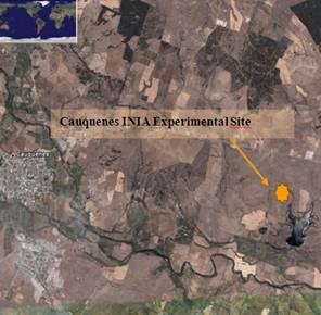
Six months of drought (October to March) render the relatively high annual rainfall of the study area far more difficult for rainfed farming than would at first appear. Aridity decreases from north to south. In the northern limit the annual rainfall is less than 300 mm per year, while the southern boundary reaches to 1000 mm annually. Long term average of the minimum temperatures of the coldest month (July) is 4.8 °C and of the maximum temperatures of the warmest month (January) is 29 °C. In Cauquenes, where the experimental sites have been placed, (Figure 4) mean annual rainfall is 695 mm with six month (October to March) of drought period.

Figure 4: Experimental area in the Experimental center of INIA Cauquenes.