Impervious surface area
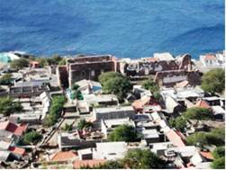
Impervious surface area or soil sealing occurs when agricultural or other rural land is taken into built environment (litorization). Soil sealing is the result of the development of housing, industry, transport and other physical infrastructure, including utilities (e.g. waste disposal) and military installations (Fig. 43). The EU Thematic Strategy for Soil Protection identifies soil sealing as one of the eight recognized threats to Europe's soil resources. One major driver of soil sealing in the Mediterranean region is population pressure. Over the last three decades the Mediterranean countries have experienced a tremendous growth in population increase. In 2000 the 22 Mediterranean countries housed 428 million people compared to 285 million in 1970. Population pressure in the Mediterranean is exacerbated also by the tourism development which is the most preferred destination for European tourists. The impacts of soil sealing expansion in conjunction with climatic changes has greatly contributes to loss of fertile agriculture soils, expansion of agriculture in marginal lands, frequent flooding in the lowland due to artificial infrastructure cover of soil surface reducing water infiltration, water pollution due to overuse of pesticides and fertilizers, soil salinity due to irrigation with saline water and decreasing ground water enrichment and sea water intrusion into the aquifers. All these processes greatly contribute to land degradation and desertification.
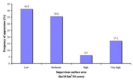
The portion of impervious surface area has been estimated for the study sites by using aerial photographs of different periods. It has been defined as the surface area sealed in hectares per 10 km2 of territorial surface per 10 years. The following classes have been distinguished: (a) low: <10 ha area sealed in a territorial of 10 km2 per 10 years, (b) moderate: 10-25 ha per 10 km2 of territorial surface per 10 years, (c) high: 25-50 ha per 10 km2 of territorial surface per 10 years, and (d) very high: >50 ha per 10 km2 of territorial surface per 10 years.


Fig. 43. Soil sealing due to cover of the soil surface with inert material causing severe problems of land degradation
Data for this indicator have been collected for 877 field sites, corresponding to 11 study sites (Table 5). As Fig. 44 shows, the dominant class of soil sealing is low (<10 ha 10 km-2 10 years-1 ), covering 43.4% of the study field sites. Such rate of soil sealing has been mainly identified in the study sites of Boteti Area-Botswana, Santiago Island-Cape Verde, Zeuss Koutine-Tunisia, Novij Saratov-Russia, Djanybek-Russia, Secano Interior-Chile, Cointzio Catchment-Mexico, and Crete-Greece. The next important class of soil sealing is moderate (10-25 ha 10 km-2 10 years-1 ), covering 35.6% of the study field sites, corresponding mainly to the study sites of Boteti Area-Botswana, Konya Karapinar plain-Turkey, Santiago Island-Cape Verde, Eskisehir-Turkey, Guadalentin Basin Murcia-Spain, and Crete-Greece. Very high rate of soil sealing (>50 ha 10 km-2 10 years-1) has been defined in 17.1% of the study field sites, corresponding to the most touristic study site of Crete and in some cases in the Santiago Island-Cape Verde site. High rate of soil sealing has been identified in few cases (6.1% of the study field sites) (Fig. 44).

Fig. 44. Distribution of impervious surface area class defined in the various study sites