Land fragmentation
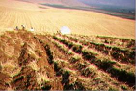
Land fragmentation can affect land management practices and decision-making related to the structure of the farm. A highly fragmented land is not easily to mechanized and cultivate in a direction in which soil erosion is restricted (Fig. 52). If the fields belonging to a farm are located in various locations then economic performance of various activities becomes less profitable and can generate the abandonment of the farm, worsening the quality of the environment. In extreme situation, marginal lands located at long distance from the farm centre can be progressively abandoned. Moreover, long distance located parcels can not easily controlled protection and maintenance of the landscape. Farm fragmentation in combination with adverse soil, topographic and climatic conditions affected land use change decision-making. Studies conducted in the island of Lesvos have shown that as the number of parcels in each farm increased, land use remained often unchanged. When a farm was divided in several parcels distributed in various locations, farmer used to allocate land uses according to the land productivity keeping such distribution usually unchanged for long periods.
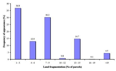
Land fragmentation has been defined as the number of parcels per holdings. Data on land fragmentation related to the study field sites have been collected by contacting the land user. The following classes have been defined for this project: (a) 1-3 parcels, (b) 4-6 parcels, (c) 7-9 parcels, (d) 10-12 parcels, (e) 13-15 parcels, (f) 16-19 parcels, and (g) >19 parcels.


Fig. 52. Land characterized as highly fragmented (left) and low fragmented (right) in which fields are uniform concerning crop and cultivation
Based on the obtained data (Table 7), land fragmentation has been defined on 918 field sites, corresponding to 12 study sites. As Fig 53 shows, the dominant class of land fragmentation in the study field sites was 1-3 parcels per holding, covering 36.8% of the study field sites, corresponding to the study sites of Secano Interior-Chile, Boteti Area-Botswana, and Konya Karapinar plain-Turkey, Santiago Island-Cape Verde, Mamora Sehoul-Morocco, Cointzio Catchment-Mexico, and Zeuss Koutine-Tunisia. The following important class of land fragmentation was 7-9 parcels, covering 30.2% of the total fields. Such conditions of land fragmentation have been mainly defined in the study sites of, Santiago Island-Cape Verde, Mamora Sehoul-Morocco, Eskisehir-Turkey, and Crete Greece. Parcels 13-15 per holding have been found in 14.7% of the study field sites, corresponding to Secano Interior-Chile, Mamora Sehoul-Morocco, and Guadalentin Basin Murcia-Spain study sites. The next important class of land fragmentation was 4-6 parcels per holding, covering 12.9% of the study sites, and corresponding to Secano Interior-Chile, Santiago Island-Cape Verde, Mamora Sehoul-Morocco, Zeuss Koutine-Tunisia, and Novij Saratov-Russia study sites. Finally, very high land fragmentation (>19 parcels per holding) was found in 4.5% of the study field sites, corresponding only to Djanybek-Russia study site (Fig. 53).

Fig. 53. Distribution of land fragmentation classes defined in the study field sites