Presence of terracing
Terraces are constructions built mainly in hilly areas to reduce water erosion losses from cultivated erodible soils and for water conservation. Terracing of hilly areas is a measure to combat desertification. Adsorption of water by the soil increases during heavy rainfall events and soil erosion is reduced in terracing land. If terraces are well designed, terraces control sheet and gully erosion by reducing slope length. Water runoff from the upper side of the terraced interval is held within the terrace, infiltrates and it is stored in the soil. Land terracing is the construction of relatively flat surfaces of reasonable size to allow cultivation of sloping areas. It is accomplished by removing strips of soil parallel to contours lines and accumulating the removed material over the soil surface just below the trench, transforming the natural slope in a stair-like anthropogenic environment. Techniques of terrace construction have been changed through centuries. In early practice, the land was shaped into a series of nearly level benches or step-like formations bounded on the lower side by an almost vertical bank usually protected by a stone wall. Modern practice in terracing, however, consists of nearly level benches constructed using machines which are wide enough to be cultivated, seeded, and harvested with ordinary machinery (Fig. 78).


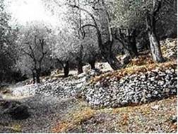
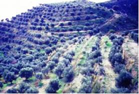
Fig. 78. Examples of traditional (left) and modern (right) land terracing
Terracing is not a natural sustainable land utilization type. Therefore, it must be properly constructed and effectively maintained, taking in consideration slope gradient and length, soil parent material and depth, avoiding exposure of highly erodible and undesirable materials. Above all economic sustainability of the terraced land must be secured for long periods of time. Otherwise, it may cause high soil erosion rates and fast and severe deterioration of land.
The assessment of land terracing has been conducted by the extent in which an area is covered by terraces. It has been defined as the ratio of the area protected to the total area, expressed as a percentage using the following classes: (a) no terracing, (b) low, <25% of the area is protected; (c) moderate, 25-50% of the area is protected; (d) high, 50-75% of the area is protected; (e) very high, >75% of the area is protected. The assessment has been made by: (a) simple field observations, or (b) aerial photography interpretation.
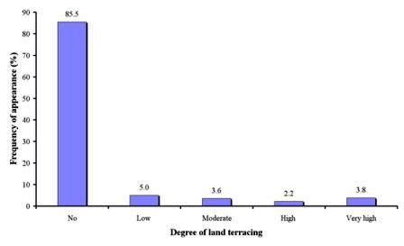
As Table 10 shows, data for this indicator have been collected in 1239 study sites, corresponding to 14 study sites. No land terracing has been identified in 85.5% of the study field sites (Fig. 79). None field sites with terracing has been defined in the study sites of Boteti Area-Botswana, Novij Saratov-Russia, Djanybek-Russia, Secano Interior-Chile, Rendina Basin Basilicata-Italy, Mamora Sehoul-Morocco, Eskisehir-Turkey, Cointzio Catchment-Mexico, and Konya Karapinar plain-Turkey, while no terracing has been defined in most of the cases of the study sites Santiago Island-Cape Verde, Guadalentin Basin Murcia-Spain, Zeuss Koutine-Tunisia, Loess Plateau-China, and Crete-Greece. All the other classes of land terracing (Fig. 79) have been found in less than 14.5% of the study field sites. The most important action for soil erosion control and water conservation using terraces has been identified in the following 4 study sites: Santiago Island-Cape Verde, Guadalentin Basin Murcia-Spain, Zeuss Koutine-Tunisia, and Loess Plateau, China.

Fig. 79. Distribution of degree of land terracing defined in the study field sites