Assessment and validation of the derived methodology
The derived methodology was assessed using independent indicators measured in other field sites. The assessment was based in the comparison of the desertification risk index with: (a) existing experimental soil erosion data, and (b) data of soil aggregate stability and soil organic matter content of the surface horizon. Soil erosion data were collected by the Agricultural University of Athens during the execution of the European Commission research projects: (a) Mediterranean Desertification and Land Use - MEDALUS I (Kosmas et al., 1993), (b) MEDALUS II (Kosmas et al., 1995; (Moustakas et al., 1995; Danalatos et al., 1995, Tsara et al., 2001), and (c) Tillage Erosion: Current State, Future Trends and Prevention - TERON (Kosmas et al., 2001; Gerontidis et al., 2001). Soil erosion data were used from nine experimental field sites under various soil, topographic, land use and climatic conditions. The measured soil sediment losses in the various rainfall events were expressed on annual average basis for comparison with land desertification risk index defined by the derived methodology in this study.
Concerning soil aggregate stability and soil organic matter content, a number of 39 soil sites were selected in the study field site of Crete. The selected sites were located in soils formed in various parent materials, under various climatic, topographic and land use characteristics. In each site, all the necessary indicators for defining desertification risk were measured. Undisturbed soil samples were taken only from the surface A-horizon for laboratory measurements. The selected soil samples were analyzed for particle-size distribution of the <2-mm fraction by the Bouyoucos hydrometer method (Gee and Bauder, 1986). The organic carbon content was measured using the modified Walkey-Black wet oxidation procedure (Nelson and Sommers, 1982). The wet sieving technique by Yoder (1936) was used for the determination of the mean weight diameter of the soil aggregates.
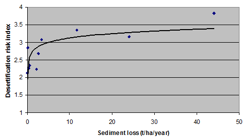
As Fig. 1 shows, annual soil erosion rates are related with desertification risk index estimated by the corresponding algorithms developed in this study. Desertification risk index increases rapidly in low rates of soil erosion (up to 5 t ha-1 yr-1) and then desertification risk index is increasing slowly while erosion rates are very high. This relation of desertification risk index and annual soil erosion rate can be attributed to the resilience of a system to withstand degradation. For example a relatively deep soil under certain climatic, vegetative and topographic conditions characterized with moderate desertification risk will remain in this class until soil depth reaches to a threshold value (less than 30 cm) where desertification risk is high with low potential of ecosystem to provide services.

Fig. 1: Relation of desertification risk index estimated by the derived methodology using the equations of Table 2 and annual soil sediment loss measured for the same sites
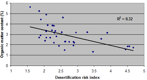
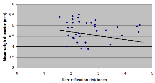
Soil organic matter represents a key indicator for soil quality, both for agricultural and environmental functions. Soil organic matter is a major indicator influencing physical, chemical, and biological soil parameters. Aggregation and stability of soil structure increase with organic matter content. This in turn increases infiltration rate and available water capacity of the soil, as well as resistance against erosion by water and wind. Decrease of organic matter content is a key factor in accelerating soil erosion and thus for irreversible land degradation and desertification. As Fig. 2 shows, desertification risk index decreases as soil organic matter content in the surface horizon increases. A similar relation has been found for soil aggregate stability and desertification risk index (Fig. 3). Therefore, the development methodology on assessing desertification risk shows a relatively satisfactory relationship with independent physical indicators such as soil erosion, soil organic matter content and a lower relationship with aggregate stability for the Crete study field sites.

Fig. 2: Relation of desertification risk index estimated by the derived methodology and organic matter content of the surface horizon measured for the same sites

Fig. 3: Relation of desertification risk index estimated by the derived methodology and soil aggregate stability of the surface horizon measured for the same sites