|
Controlled grazing, use of tillage and herbicides in olive groves
Authors: Agricultural University of Athens
Agia Babara monitoring area
|
|
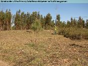
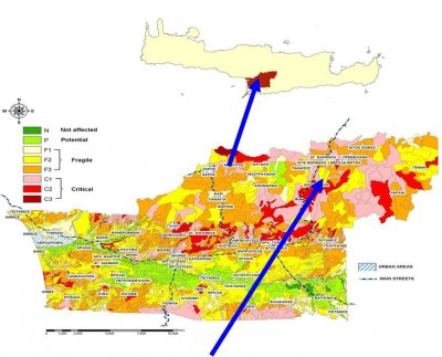
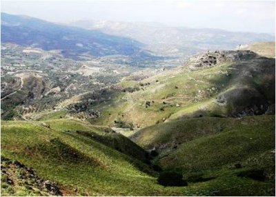
The location comprises grazing land. The field is located on sloping land (slope gradient 23%) with moderately deep soil (soil depth 45-60 cm) which is prone to surface water runoff erosion. Rills of water erosion are observed in places where runoff water is concentrated. Water stress to the growing plants is also a major issue in the area especially in the south-facing slopes since the soil water storage capacity is relatively low. The average annual rainfall is 970 mm with a rain season period from October to early May. Evaporation ranges from 1370 to 1570 mm per year.
|
 |
|
|
Stakeholder involvement: The local stakeholders are very interested in the degradation of their grazing land. They have recognized how adversely the land is currently managed. They have promised to protect the land, even to reforest part of it, on the condition that their income will be supported by local or governmental administration. The farmers pass the monitoring site every day because it is located near the road. A seminar has been organized in their village explaining the problem of desertification and how to protect the land. Wider attention is going to be given after presenting the results of monitoring and organizing visits for officials to the monitoring area to explain the SWC techniques and to provide them with the results that have been obtained. |
Conservation measures and experimental setup
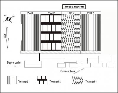 |
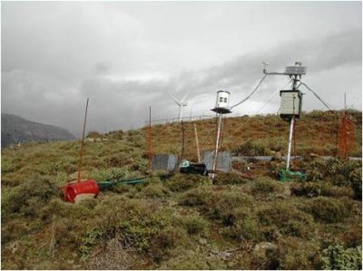
Experimental setup: One field has been divided in two parts. One part with two plots under controlled grazing and the other has been subjected to overgrazing (see study site experimental design). At the bottom of each plot there is a small ditch collecting runoff water and leading to a dipping bucket and a sediment trap. An automatic meteorological station has been installed nearby.
Expected effects: Controlled grazing will reduce surface water runoff and sediment loss. Furthermore, soil water conservation, organic matter content, and structure stability will be enhanced.
|
| Monitoring activities |
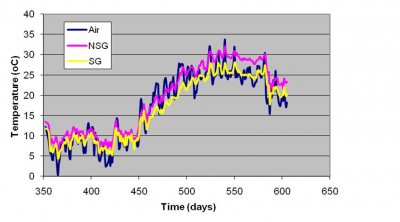
- Continuous meteo measurements by an automatic station: rainfall, wind speed, air temperature, relative humidity, net solar radiation.
- One-off soil measurements: texture and stoniness, organic matter, saturated hydraulic conductivity, porosity, Ksat, and bulk density.
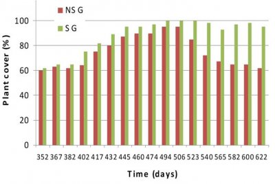
- Repeated visual monitoring supported by digital photography: Regular soil surface assessment, plant cover, erosion features.
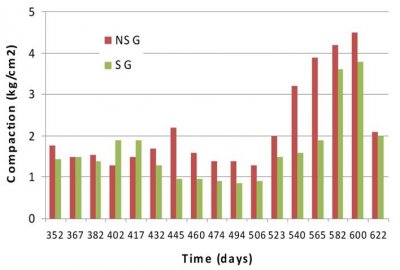
- Repeated measurements: soil moisture, soil temperature, sediment loss every rainfall event, surface water runoff, soil shear strength, and soil compaction.
- Agronomical activities by stakeholder: Number of animals grazing, period of grazing etc.
- Yield assessment: Total milk production in kg/ha, general impression by stakeholder, comparative assessment with regular practice.
|
Important results
- Measurements have been conducted from middle of middle of December 2008 to end of September 2009.
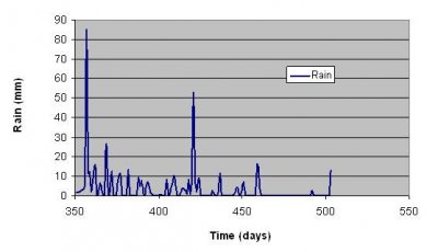
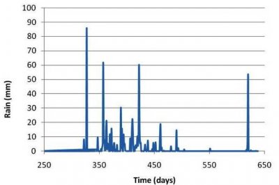
- Total rainfall for the above period reach 569.8 mm with two major events with maximum rainfall intensity 31.2 and 50.4 mm/h.
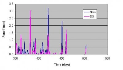
- Four major surface water runoff events occurred. There was a change in total runoff and sediment loss: Sustainable grazing (SG)=14.7 mm, 76.8 kg/ha; unsustainable grazing (NSG)=23.5 mm, 123.2 kg/ha.
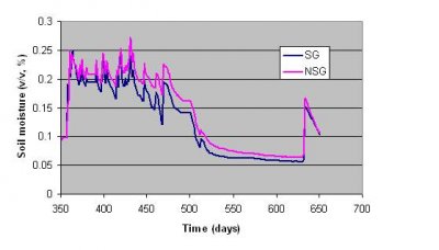
- Soil moisture at 20 cm 40 cm depth was affected by land management practices with higher soil moisture content in the NSG practice.
- Soil temperature at 10 cm depth was higher in the NSG. The average soil temperature for the above period was 18.7 °C, and 16.3 °C for the NSG, SG, respectively.
- Soil compaction, shear strength values were higher the NSG.
- Plant cover change with time with average 75.1% and 88.5%, for NSG and SG, respectively.
|
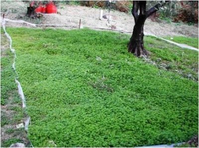
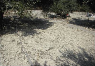
Monitoring has been conducted in an olive grove. The soil is characterized as moderately deep soil (soil depth 55-65 cm), moderately steep slope (slope gradient 17%), formed on marl parent material, prone to surface water runoff and tillage erosion. Water stress to the growing plants is also a major issue in the area since climate is semi-arid and water for irrigation is not available. The average annual rainfall is 570 mm with a rain season period from October to early May. Evaporation ranges from 1370 to 1570 mm per year.
|
 |
|
|
Stakeholder involvement: The landowner is very interested in the research work carried out in his land. People in the village have been informed of the monitoring activities that are being carried out. Farmers have realized the importance of no-tillage farming in olive groves, taking into consideration the reduction in labour and increase in net income. Issues concerning land management and protection of olive groves from soil erosion and land desertification are considered very important by the local farmers. Stakeholders are very interested to have the results of DESIRE and to use new technologies on land management and protection of the environment. Wider attention is going to be given after organizing visits for officials to the monitoring area to present the implementation and to provide them with the DESIRE results. |
Conservation measures and experimental setup
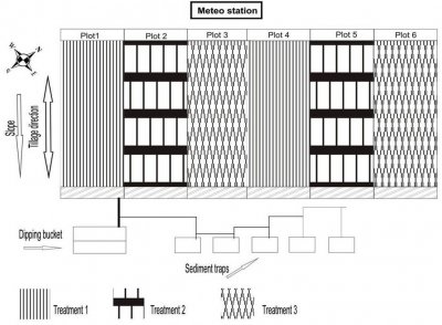 |
Experimental setup: The field experiment includes three treatments with two replicas (see map). The following three treatments are applied: (a) treatment 1, no tillage – no herbicides application, (b) treatment 2, no tillage – herbicides application, and (c) treatment 3, tillage operations perpendicular to the contour lines at depth 20 cm using a disk. At the bottom of each plot there is a small ditch and a tube that leads runoff water to a dipping bucket and soil sediment trap. Measurements are automatically controlled.
Expected effects: No tillage or herbicides application will reduce surface water runoff and sediment loss. Furthermore, soil water conservation, organic matter content, and structure stability will be enhanced.
|
| Monitoring activities |
- Continuous meteo measurements by an automatic station: rainfall, open pan evaporation, wind speed, air temperature, relative humidity.
- One-off soil measurements: texture and stoniness, organic matter, saturated hydraulic conductivity, porosity, Ksat, and bulk density.
- Repeated visual monitoring supported by digital photography: Regular soil surface assessment, crop characteristics, plant cover, erosion features,
- Repeated measurements: soil moisture, soil temperature, sediment loss every rainfall event, surface water runoff, soil shear strength, soil compaction.
- Agronomical activities by stakeholder: dates and type of tillage operations, application of chemicals/fertilizer, etc.
- Yield assessment: total yield in kg/ha, general impression by stakeholder, comparative assessment with regular practice.
|
Important results
- Measurements have been conducted from the middle of November 2008 to the end of September 2009.
- Total rainfall for the above period reach 704.4 mm, with one major event with maximum rainfall intensity 74.4 mm/h.
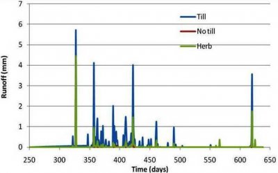
- Four major surface water runoff events occurred. There was a great difference in total runoff and sediment loss between the land management practices: tillage= 46.9 mm, 123.2 kg/ha; herbicides =13.5 mm, 60.6 kg/ha; and no tillage-no herbicides =2.9 mm, 8.9 kg/ha.
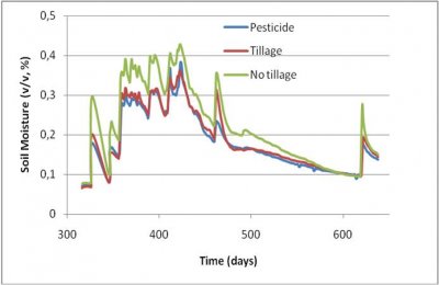
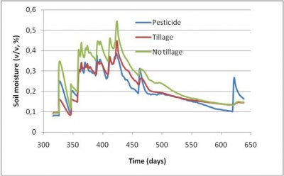
- Soil moisture at 20 cm and 40 cm depth was affected by land management practices (LMP), with higher soil water conservation in the no tillage plot.
- Soil temperature at 10 cm depth was higher in the tillage LMP.The average soil temperature for the above period was 14.8 °C, 17.6 °C, and 18.0 °C for the no tillage, herbicides, tillage LMP, respectively.
- Soil compaction, shear strength, and plant cover values were higher in no tillage LMP, followed by herbicides application, and tillage LMPs.
|

