Further info
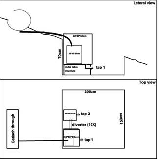
A total of 15 Gerlach throughs will be installed in Field site A (i.e. 9) and C (i.e. 6). The Gerlach throughs will be used to collect sediment and runoff discharge after each rainfall event (see Figure 5). In order to collect the runoff, a diverter will be installed after the first storage tank. Assuming a rainfall event of 50 mm, a runoff ratio of maximum 20% and a plot size of 20m², a maximum of 200 L runoff is expected. The plots will be semi-closed: no hard structures will be used to close the plots but in order to be able to know the size of the plots and source areas of the collected sediments small earthen-walls (~20cm height) will be put into place in order to prevent runoff going form one plot to the other.

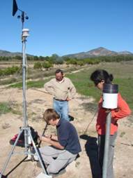
Photo 4: Automatic meteorological station installed near the farm of los Alhagüeces (Photo by Jorge López).
Laser scanning will be used to make a detailed Digital Elevation Model of each experimental field. This will be used to extract the contributing drainage area of each of the Gerlach throughs and to convert soil mass (kg) to an area-specific erosion rate (kg/m²).
Runoff entering the Boquera field site will be measured in a stabilized (cemented) section with a pressure head measurement connected to a data logger. Information on the volume of water may be used later for extrapolation to other parts of the catchments based on a DEM and rainfall data or by a runoff ratio. This may help to identify potential areas for water harvesting.

Figure 5: Design of the Gerlach erosion throughs with storage tanks to collect runoff water and sediments