Floodwater harvesting
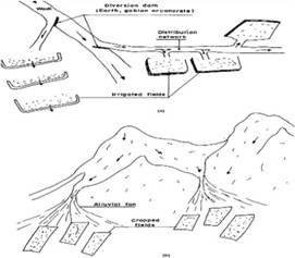
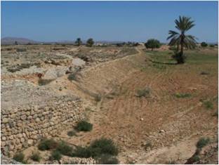
Floodwater harvesting systems divert the total, or a portion, of the floodwater carried by wadis to neighboring cultivated fields, so providing natural irrigation. The remnants of such systems, together with many still-functioning units are shown in Photo 3. It seems that this technique has been practiced since Roman times, and may even have been practiced in the pre-Roman period. However, El Amami (1984) believes that the arrival of the Arabs, who brought with them from Yemen immense experience of similar environments, was behind the adoption and the perfection of this technique on a large scale.
Floodwater harvesting is presently applied in regions characterized by very large watersheds, with wadis which can be as wide as 1000 m, and up to 100 km long and up to 4 m deep (e.g. Zeroud, Merg Ellil, Esserg). Floods generally occur during two main periods: September-October and March-May. However, they can occur at any time of the year. The yield of sediment from the wadis is very important for fertilizing the soil (Ennabli 1993). Mean annual rainfall ranges between 200 and 400 mm. Hénia (1993) found that this region has the most variable rainfall regime and the highest rainfall intensity of all Tunisia's regions (more than 300 mm/day recorded maximum).
|
Figure 1: Scheme of flood spreading: a: artificial spreading, b: natural spreading. |
Photo 3 : Floodwater harvesting an Wadi Nkim(Bhaira) |

