Major natural resources
The eruptive Complexo of Pico da Antónia (PA) covers a large expanse of the basin. It is a highly diversified lithological complex, comprising rocks that are part of different geological episodes, whether volcanic, sedimentary or continental (Serralheiro, 1976; Bertrand, 1996; Costa, 1996). In this complex, the volcanic rocks are more abundant and are formed in majority from sub-aerial eruptions that produced pyroclasts and breccias, predominantly in the interior of the basin, and basaltic lava, more extensive and thicker towards the coast (Costa, 1996).
The Ribeira Seca basin reflects the general morphology of Santiago, having very rough mountains. From the spring to the mouth of the creek, the following can be distinguished:
- The massive mountain of Pico da Antónia (1394m), the highest of the Island and oriented in a SE-NW direction. This formation dominates elongated hills and valleys with steep slopes and plain bottoms. On the east side (where the study site is located) the landscape is greener and much richer in species (fauna and flora). Nevertheless, on the side facing west, the ecosystems are extremely arid.
- The rocky scarps form an effective rocky barriers against the N-NE humid winds in the W-SW part of the basin.
- The cliffy slopes of the Pico de Antónia and Órgãos formations are practically straight, with very steep slopes on top.
- The achadas (plateaus) of low and medium altitude, essentially in the downstream part of the basin present a relatively flat relief.
- The channels of the main water courses, especially in the downstream areas, are encased, with wide valley bottoms, due to fillings with sediment.
Table 1: Physiographical characterization of the study site
| Index | ||
| S (km²) | Drainage area | 71.50 |
| P (km) | Perimeter | 39.47 |
| Alt. Max (m) | Maximum altitude | 1394 |
| Alt. Min (m) | Minimal altitude | 0 |
| Kf | From factor | 0.22 |
| KG | Compactness coefficient | 1.31 |
| Kr (%) | Average slope of the main creek | 7.20 |
| Kb (%) | Average slope of the basin | 8.60 |
| Am (m) | Average altitude | 290 |
| Ra [-] | Elongation coefficient | 0.5 |
| Lb (km) | Length of the main water course | 18.0 |
| Dd (km-1) | Drainage density | 0.51 |
| C (km) | Elasticity constant of the water course | 1.96 |
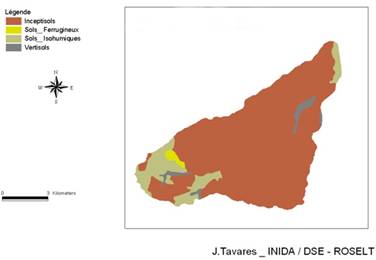
Due to the influence of microclimates in the basin, several types of soil occur. In the pedological characterization of the agro-ecological units, Dinis and Matos (1986) in "Os Solos da Ilha de Santiago" general study of Faria (1970), identify the various types of soil according to the climatic zones and the main geomorphological situations. Table 2 shows the soil distribution in Ribeira Seca in function of the climatic zones and the geomorphology according to the US classification, Soil Survey, U.S.A. (1975), while Figure 6 shows a map representing the soil classes in the watershed.

Figure 6: Soil map of Ribeira Seca
Table 2: Soil distribution in function of the climatic zones and the geomorphology according to the English classification, Soil Survey, U.S.A. (1975).
| Bioclimatic zones | Beach | Valley | Achadas (Plateaus) |
Slope surfaces | Rough altimetry | Volcanic cones |
| Arid | Entisols | Entisols Inceptisols |
Aridisols Vertisols Inceptisols |
Entisols Inceptisols |
Entisols Inceptisols |
Entisols |
| Semi-arid | _ | Entisols | Aridisols Mollisols Vertisols |
Aridisols Mollisols |
Aridisols Entisols |
Inceptisols Aridisols |
| Subhumid | - | Entisols Inceptisols |
Mollisols Inceptisols |
Inceptisols Mollisols Entisols |
Inceptisols Entisols |
Inceptisols Mollisols |
| Humid | - | - | - | - | Inceptisols Mollisols |
Inceptisols Mollisols |
Source: adapted from Dinis & Matos (1986).
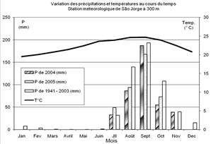
The climate of Ribeira Seca, as that of the entire country, is characterized by two seasons: a dry one that lasts 8-9 months from November to June and a short humid one, 2-4 months from July to October. The humid period coincides with high temperatures (Figure 7). All the agricultural life of the basin and archipelago is connected to the amount of rain that falls during the rainfall period. The rain is generally extremely heterogeneous and its distribution in time and space is irregular.
 |
 |
Figure 7: Average monthly and annually rainfall (mm) and temperature variation in the São Jorge station (sub-humid zone) |
Figure 8: Cartography and quantification of the different bioclimatic zones in Ribeira Seca watershed |
The climatic conditions regulate the development of the vegetation. According to Diniz and Matos (1987), the basin presents four bio-climatic zones. The following map and graph give the cartography and quantification of the zones, respectively (Figure 8).
- A humid zone is located in the spring of the basin and includes the Pico da Antonia, Longueira, Ribeirão Galinha and Maton sub-basins. The annual rainfall may reach or even exceed 800mm. This region comprises one of the main dense forest perimeters of the island, which has an approximate area of 7.73km².
- A sub-humid zone of approximately 14.38km² (20.11%), where the precipitation varies between 400-700mm.
- A semi-arid zone (the most extensive of the basin) with a surface of 35.37 km² (49.34%). In this area, the rainfall is less than 400mm. It is a typically agricultural zone, with some grazing land parcels and forestalls species of Prosopis juliflora, Azadirachta indica, Acacia holocericea.
- An arid zone of around 14.11km², with rainfall inferior to 200mm, very poor in woody vegetation with some species of: Prosopis juliflora, Ziziphus indica and others.
In the rainy periods, the water-bearing stratum, reservoirs and others are fully filled and the population and crops are well-supplied. However, in drought periods or with less rain, a crisis exists in all the sectors: the agricultural production is deficient, and the population and animals suffer from lack of water.
Just as in the three sub-basins Longueira (humid to sub-humid), Ribeira Grande (semi-arid) and Godim (semi-arid to arid), the hydrographical net of Ribeira Seca is well developed. In the flood periods, 58% of the basin drainage waters drain to the sea, whereas the rest of it directly feeds the Poilão dam.