Major degradation issues due to the use of natural resources - analysis
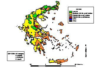
As it was mentioned previously, Crete has subjected for a long period an overexploitation of natural resources. Large scale deforestation of the sloping lands accompanied by intensive cultivation and overgrazing resulted in accelerated erosion and the formation of badlands with very shallow soils through the progressive inability of the vegetation and soils to regenerate themselves. Based on the land desertification risk map of Greece compiled by the Greek National Committee for Combating Desertification (Figure 16), more than 50 of the island is characterized by high desertification risk. The high erosion rates occurring in the island of Crete are attributed to the climatic conditions, to topographic characteristics and to the generally poor vegetation cover. Semi-arid landscapes by definition are water-limited and therefore are potentially sensitive to environmental change and its effect on biomass production. These areas become vulnerable to erosion because of the reduced protection of the ground surface by vegetation from heavy rains with high intensity.
Figure 16: Potential desertification risk nap of Greece (compiled by the Greek National Committee for Combating Desertification)
In the last decades, favourable soil and climatic conditions and the availability of ground or surface water has resulted in intensive farming of the Mediterranean lowlands. The development of high input agriculture in the plains provided much higher net outputs than those obtained from the old fashion terraced agriculture. In many cases, the rapid development resulted in the over-exploitation of the aquifer system for a variety of uses causing gradual intrusion of sea water in the aquifers. Irrigation using water with high salt concentrations increased the salinity of the soil, rendering an unproductive desertified land. Soil salinization is a potential desertification threat for lands located manly along the coast characterised by high xerothermic climatic indices. Moreover, as tourism continuously grows, water allocation will be shifted towards domestic consumption. The increasing water consumption combined with the substantial increase in water requirements associated with high input agriculture is likely to create a significant water allocation problem bringing about further degradation of the plains through salinization.
Soil erosion
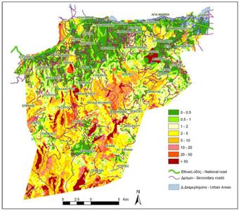
The Chania region. By using the soil, topography, and vegetation characteristics of the Chania region the PESERA model was applied using the climate characteristics of the year 2000. As Figure 17 shows, soil erosion is a major issue of land degradation in the area of Chania. The assessed soil erosion rates are especially high in the upper part of the study area. Such areas are characterized by the following characteristics: steep slopes, relatively shallow soils, high soil erodibility especially in soils formed on shale parent materials, low infiltration rates in soils formed on marl and conglomerate deposits, moderate to poor plant cover, removal of understory annual vegetation in olive groves, burning and overgrazing of natural vegetation, clearing of natural vegetation and planting olives without taken actions for soil erosion, and heavy rainstorms occurring frequently in the area.
Figure 17: Soil erosion rates (t ha-1 yr-1) estimated by the application of the PESERA model for the Chania pilot area (year 2000)
![]()
Table 5: Distribution of soil erosion rates for Chania estimated by the PESERA model using the meteorological data of the year 2000
The erosion rates estimated by the application of the PESERA model are relatively high under the existing land management practices. The dominant class of soil erosion was 2-5 t ha-1 yr-1 covering 21.1% of the total area (Table 5). Such soils are located in areas with relatively steep slopes (slope gradient >25%), soils formed mainly on shale or conglomerates, partially covered with perennial or annual vegetation.
The following important classes of soil erosion are 1-2 t ha-1 yr-1 and 0.5-1 t ha-1yr-1 covering 17.8% and 16.4%, respectively. Such areas are mainly located in the northern and central part of the study area with relatively steep slopes (slope gradient >12%), and soils formed mainly on shale or marl deposits. Areas with erosion rates 5-10 t ha-1 yr-1) cover relatively smaller areas (11.9% of the total area). Such soils are mainly located in the south and central part of the study area with very steep slopes (slope gradient >35%), formed mainly on shale or conglomerates, and vegetation is mixed olive groves with shrubs or unmixed shrubs. Areas under very high erosion rates with classes 10-20 t ha-1 yr-1, 20-50 t ha-1 yr-1, >50 t ha-1 yr-1 covering 5.1%, 3.7% and 3.9%, respectively, are characterized with very steep slopes, low plant cover (new olive groves, bare land, degraded pastures) and shallow soils. Plain areas or slightly sloping areas (slope gradient less than 6%) well vegetated are characterized al low erosion risk. These areas are characterized as having less than 0.5 t ha-1 yr-1, and cover 20.1% of the study area.
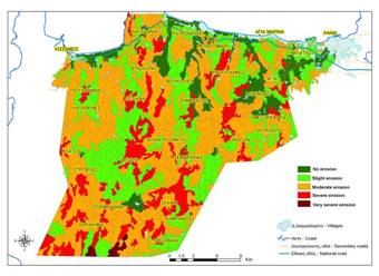
Similar characteristics of soil erosion have been recorded by assessing the degree of soil erosion. As Figure 18 shows, the majority of the area (46.5%) is characterized as having moderate degree of soil erosion (Table 6). Such areas are distributed almost along the whole study area corresponding in pastures and olive groves land uses. The next important class of degree of soil erosion is slight erosion covering 28.9% of the total area. Such classes are mainly found in hilly areas cultivated with olive groves which are usually subjected to no-tillage operations with the annual vegetation growing under the trees. Severe erosion has been estimated in an area of 10,521 ha or 15.1% of the total area. These are hilly areas with steep slopes subjected to intensive cultivation or overgrazing. No erosion has been recorded mainly in gentling or slightly sloping lowlands covering 8.8% of the total area.
Figure 18: Degree of soil erosion for Chania region as estimated in the soil survey
![]()
Table 6: Distribution of degree of soil erosion for Chania estimated during the soil survey (total area estimated 69,624 ha)
As it appears from the above analysis, soil erosion is a major process of land degradation in the hilly areas of Chania cultivated with olives or used as pastures, under the existing land management practices. Soil erosion is greatly affected by the type of parent material and the land management practice. The main existing parent materials in which soils are formed are classified with the following order of decreasing sensitivity to soil erosion: shale <conglomerates <marl. Therefore, priorities for actions protecting the area from degradation have to be given in the order in which parent materials are classified. Areas with shale, which are the most widely expanded in the pilot area, are the most sensitive to erosion and degradation.
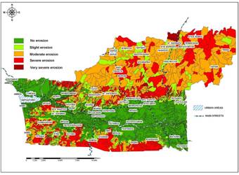
The Messara valley. The present situation of degree of soil erosion in the Messara valley was assessed during the execution of the soil survey. As Figure 19 shows the bottom of the valley is characterized with no erosion (total area 11,754 ha, or 31.9%) since the area is almost flat (Table 7). Some of this area receives soil materials eroded from the surrounding hills or transported by the Geropotamos river and deposited in the recent lower alluvial plain. The surrounding hilly areas are mainly moderately to severely eroded covering 34.1% and 21.3%, respectively. Slightly eroded areas cover 12% of the total area. Soil erosion is attributed to both surface water runoff (pastures, olive groves, and vineyards) and tillage operations (olive groves and vineyards). Therefore, one of the main processes of land degradation and desertification for the Messara valley is soil erosion.
Figure 19: Degree of soil erosion estimated during the soil survey of the Messara valley
![]()
Table 7: Distribution of degree of soil erosion for Messara valley Chania estimated during the soil survey (total area estimated 36,734.6 ha)
Soil salinization risk
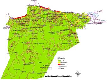
The Chania region. Soil salinization risk in the Chania region is mainly confined in the lower part in a narrow zone along the coast (Figure 20). The soils of these areas are characterized as poorly to very poorly drained with ground water table fluctuating between 30 to 150 cm during the year. The total area characterized as subjected to high salinization risk is 430 hectares or 0.6% of the total area, while areas characterized with moderate salinization risk cover 717 hectares or 1.0% of the total area. The rest of the area is characterized as low or no risk for soil salinization. These areas will be affected by salts only if poor quality of water will be used for irrigation.
Figure 20: Soil salinization risk map of Chania region (western Crete)
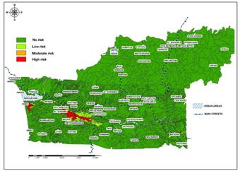
The Messara valley. Soil salinization is an important process of land degradation mainly in the lowlands of the Messara valley or along the coastal lines (Figure 21). Areas under high salinization risk cover an area of 368.1 ha or 1% of the total area. These soils are characterized as almost flat, moderately fine or fine-textured with ground water table fluctuating between 30 to 120 cm during the year. Areas with moderate salinization risk cover only a small percentage ( <0.1%) of the total area. Areas with low salinization risk usually are surrounding the areas of high risk covering 1.4% of the total area. The rest of the area is characterized as subjected to no salinization risk since ground water is very deep (deeper than 10 meters) minimizing the risk of soil salinization due to capillary upward movement of water. Of course salinization risk becomes high in the case that the land is irrigated with poor quality of water.
Areas which are characterized as subjected to high or moderate salinization risk have certain land and management characteristics. The analysis of data showed that important indicators for defining desertification risk are related to land management, climate, soil, topography, and water characteristics. Important indicators related to management characteristics are frequency of flooding, land use type, and efficacy of reclamation. As the frequency of flooding increases desertification risk increases. Frequency of flooding is also related to other important indicators such as topography and depth of ground water. Desertification risk decreases as land use type changes from pasture, wetland, recreation area, and agriculture. Reclamation of salt-affected areas was mainly related to the presence of a drainage network. As the efficacy of reclamation increased due to lowering of ground water increased desertification risk decreased.
Other important indicators defining desertification risk in salt-affected areas are: distance from seashore, elevation, water quality, ground water depth, drainage and rainfall. Desertification risk increases as the distance from seashore and elevation decreases. Good ground water quality decreases desertification risk. The worst the soil drainage conditions are the higher the desertification risk is. Also the shallower the ground water table is the higher the desertification risk is. Reduction of annual rainfall increases salinization and desertification risk.
Figure 21: Soil salinization risk map of the Messara valley
Water stress
The Chania region. Air temperature (along with other climatic parameters such as rainfall) is an important indicator affecting the xerothermic index of an area. It is a critical environmental factor in determining water stress which affects the evolution of natural vegetation and may cause reduced vegetation cover. Also air temperature in semi-arid and arid climates affects water evaporation from the soil surface and plant transpiration.
High temperatures and frequent droughts are considered as the most important factor affecting the evolution of plant communities in the area. The various ecosystems have a great capacity for adaptation and resistance to high air temperatures and prolonged drought. Extreme conditions of high temperatures and, either atmospheric or soil drought, cause plant stress. The severity and the duration of the stress determine the extent of the resulting plant damage. Short periods of stress damage the plants and reduce their potential for growth but do not kill them. Prolonged stress increases the damage and eventually kills the plants
Rainfall is an important parameter controlling soil erosion, soil salinization, and development of vegetation. Together with the other climate indicators it contributes to forming a scale of climate quality and consequently to the elaboration of development strategies compatible with the resources available in the given area. Rainfall amount and distribution are the major determinants of biomass production on hilly lands under Mediterranean conditions. Decreasing amounts of rainfall combined with high rates of evapotranspiration drastically reduce the soil moisture content available for plant growth. Reduced biomass production, in turn, directly affects the organic matter content of the soil and the aggregation and stability of the surface horizon against erosion.
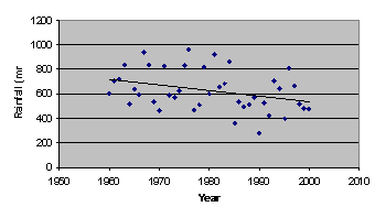
Climatic data for the study area are available from three meteorological stations (Souda, Tauronitis, and Kandanos) but long term data (last 40 years) are available only from Souda mereo station. Based in this station, the average annual rainfall is 627 mm for the study area. As Figure 22 shows, there is a trend for rainfall decreasing in the last decades for the Chania region. Based on the last 40 years data, the decrease in rainfall is estimated to 24.5%.
Figure 22: Rainfall distribution in the Chania region for the period 1960-2000 (source: National Meteorological Service, Souda station)
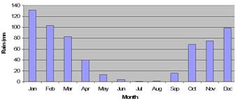
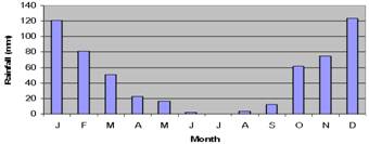
As Figure23 shows, the irregular annual distribution and the scarcity of rainfall during the dry period (May-September) favours high water deficit in the growing plants. The total amount of rainfall during from May to September is 35 mm, while the potential evapotranspiration for this period is estimated more than 850 mm. Plant growth for vegetables and citrus without supplying water by irrigation is not possible during that period. Olive trees can survive under the existing dry climatic conditions of the area without irrigation but the decrease in olive production can be more than 50% as compared to irrigated land.
Figure 23: Average monthly rainfall distribution in the area of Chania (source: National Meteorological Service)
Aridity index is an index of the average water available in the soil, defined as the ratio between mean annual precipitation (P) and mean annual evapotranspiration (ETo). It is a critical environmental factor affecting the evolution of natural vegetation and therefore rain erosivity by considering rainfall and air temperature. The aridity index classifies the type of climate in relation to water availability. The higher the aridity index of a region the greater the water resources variability and scarcity in time, the more vulnerable the area to desertification.
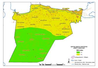
Based on the available climatic data of the following meteorological station (a) Chania, (b) Tauronitis, and (c) Kandanos, the study area is divided in the upper zone which is more wet with lower aridity index (BGI = 103) and the lower more dry zone (BGI = 155) (Figure 24). The upper wetter zone covers 47.8% and the lower less wet zone covers 52.2% of the total area.
Figure 24: Map of aridity index defined by the Bagnouls-Gaussen index for the study area of Chania
Potential evapotranspiration in relation to soil and climate characteristics determines the needs for water to the growing plants. Irrigation water requirements can be defined as the amount of irrigation water in addition to precipitation required to produce the desired crop yield and quality and to maintain an acceptable salt balance in the root zone. This quantity of water must be determined for such uses as irrigation scheduling for a specific field and seasonal water needs for planning, management, and development of irrigation projects.
Evaporation of water from the soil and plant surfaces and transpiration from the stomata cavities of plants account for more than 98 percent of the crop water use of most plant species. Evaporation and transpiration are difficult to measure because the rate of water vapour movement from several surfaces into a dynamic environment varies with time. The process of making measurements can alter the local climate around the plant and change the actual rate of evaporation or transpiration. Therefore, for most irrigation applications, evaporation and transpiration fluxes are combined and are called evapotranspiration.
The potential evapotranspiration in Crete varies from 1,370mm/yr to 1,570 mm per year. The mean annual actual evapotranspiration has been estimated to represent 75% to 85% of the mean annual precipitation in low elevation areas (less than 300m ASL) and 50% to 70% in high elevation areas (Regional Governor of Crete, 2002). The rainfall seasonality index (SI) is 0.69 which characterize the precipitation regime of the area as "seasonal". Therefore, under the high evapotranspiration demands and the high rainfall seasonality of the Chania region, plants will be subjected to high water stress during the summer period. The degree of water stress will be also related to soil water storage capacity.
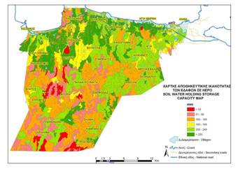
Soil water storage capacity has been determined based on soil characteristics. As Table 8 shows, the major soil water storage capacity classes are 101-150, 151-200, and 201-250 mm of water covering 22.9%, 19.5%, and 21.8% of the total area. Classes of very high ( >250 mm water) and very low (50-100 mm water) soil storage capacities are almost equally distributed in the study area (16.3%). Areas in which soil has been completely or almost washed out by erosion (soil depth usually less than 15 cm) have very low water storage capacity (less than 50 mm of water). Under such conditions natural vegetation is highly degraded with dominant plant species Mediterranean machia (frygana).
Figure 25: Map of soil water storage capacity distribution classes of the study area of Chania
![]()
Table 8: Distribution of soil water storage capacity classes in the study area of Chania
As Fig 25 shows, good soils with high water storage capacities ( >150 mm) are mainly located in the northern part of the study area. Soils in theses areas are relatively deep (soil depth >100 cm), medium- to fine- textured, formed on alluvial deposits, marl, shale or conglomerate parent materials. Soils with intermediate values of water storage capacities (100-150 mm) are mainly located in central part of the study area characterized as moderately deep (soil depth 60-100 cm), medium- to fine textured, and formed mainly on marl, shale and conglomerate parent materials (Figure 20). Soils with lower values of water storage capacities ( <100 mm) are mainly found in the central and southern part of the study area characterized as relatively shallow (soil depth <40 mm), formed mainly on shale and limestone parent materials.
Messara valley. The climate of the Messara valley is characterized with mild moist winters and dry, almost cloud-free, hot summers. The average annual rainfall, based on the meteorological station of Gortis, is 570.5 mm for the Messara valley. As Figure26 shows, the irregular annual distribution and the scarcity of rainfall during the dry period (May-September) favours high water deficit in the growing plants. The total amount of rainfall during the period May to September is 35.1 mm, while the potential evapotranspiration for this period is estimated more than 870 mm. Plant growth for vegetables and citrus without supplying water by irrigation is not possible during that period. Olive trees can survive under the existing dry climatic conditions of the area without irrigation but the decrease in olive production can be more than 50% as compared to irrigated land.
Figure 26: Annual rainfall distribution in the Messara valley (source: Greek National Meteorological Service)
Although the Messara valley receives on average 570.5 mm of rainfall per year it is estimated that about 65 % is lost to evapotranspiration, 10 % as runoff to sea and only 25 % goes to recharging the groundwater store. Rainfall increases with elevation from 570 mm in the plain areas to about 800 mm on the Valley slopes while on the Ida massif the annual precipitation is about 2000 mm and on the Asterousian mountains is 1100 mm.
Based on the available climatic data of the Gortis station, the Messara valley is characterized with high aridity index (BGI = 217) and the upper wetter zone (BGI = 145). Pan evaporation is estimated at 1500 ± 300 mm per year while the winds are mainly westerly. The potential evaporation is estimated at 1300 mm per year (Vardavas et al., 1996) and the ratio of mean annual rainfall to potential evaporation for the Valley is about 0.5 and hence it is classified as dry sub-humid according to UNCED (1994) definitions. The rainfall seasonality index (SI) is 0.83 which characterize the precipitation regime of the area as "marked seasonal with a long dry season". Therefore, the high aridity and rainfall seasonality indices in relation to the high evapotranspiration demands create adverse climatic conditions with high water stress for the growing plants, especially during the summer period. Water stress is further related to the soil water storage capacity of the soils. Soil depth affects the root depth which when it is decreased below a critical value, water stress becomes serious treat for the growing plants leading to desertification.
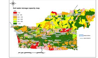
Soil water storage capacity has been determined based on soil characteristics (Figure 26). As Table 9 shows, the major soil water storage capacity class is >250 mm of water covering 39.5% of the total area. Classes o101-150 and 151-200 mm of water covers almost equal areas 20.4% and 18.2%, respectively. Areas with soils of low (50-100 mm) and very low ( <50 mm) cover 12.5% and 4.4%, respectively. Theses areas are characterized with high desertification risk since the soil water storage capacity is low due to shallow soil depth and creating adverse conditions for the growing vegetation. These areas has been highly eroded in the past with the rock (limestone or flysch) appearing in the soil surface in many cases. Under such conditions natural vegetation is highly degraded with dominant plant species Mediterranean machia (frygana) growing.
Figure 27: Map of soil water storage capacity distribution classes of the study area of Messara valley
![]()
Table 9: Distribution of soil water storage capacity classes in the study area of Messara valley
As Fig 27 shows, good soils with high water storage capacities ( >150 mm) are mainly located in the lowland of the valley. Soils in theses areas are relatively deep (soil depth >100 cm), medium- to fine- textured, formed on alluvial deposits, marl, or conglomerate parent materials. Soils with intermediate values of water storage capacities (100-150 mm) are mainly located in then hilly areas of the valley characterized as moderately deep (soil depth 60-100 cm), medium- to fine textured, and formed mainly on marl, and conglomerate parent materials (Figure 26).
Environmentally sensitive areas to desertification (ESAs)
Chania region
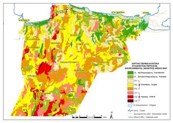
Based on the stage of land degradation and the sensitivity to desertification four categories of environmentally sensitive areas (ESAs) were found in the study area of Chania, namely fragile, critical, potential and non-threatened. The most widely extended ESAs areas are fragile (66.1% of the total area) followed by critical (15.5%), potential (10.8%) and non-threatened areas (7.7%) (Figure 27, Table 10).
Fragile ESAs: Fragile ESAs (F1, F2, F3) are widely expanded in the whole study area (Figure 28). These areas are very sensitive to degradation under any change to the delicate balance of climate, and land use. The soils of these ESAS are mainly found mainly in steep to gentle sloping slopes, moderately fine-textured, stony in some cases, moderately deep to deep, well drained formed mainly on marl, shale, and conglomerates parent materials. The climate is mainly dry sub-humid with rainfall greater than 660 mm, and a very dry aridity index (AI >150). These areas are mainly found on north-facing slopes, or occasionally on south-facing slopes. The dominant vegetation is olives and in some cases shrubs or Mediterranean macchia, characterised by a moderate to low fire risk, moderate to high erosion protection, high resistance to drought, and vegetation cover usually greater than 75%. These areas are under moderate land use intensity and moderate or complete enforcement of the policy for environmental protection.
Figure 28: Map of environmentally sensitive areas to desertification of the study area of Chania (N=non-threatened, P=potential, F1, F2, F3=fragile, and C1, C2, C3=critical areas to desertification)

Table 10: Distribution of environmentally sensitive areas to desertification defined in the Chania region
Critical ESAs: The critical areas (C1, C2, and C3 in the map) covering 15.5% of the total area (Table 10), are mainly located in the central and south part of the study area (Figure 27), have badly degraded with very shallow (depth 0-15 cm) to shallow (15-30 cm) soils severely to very severely eroded, and poorly vegetated. They are areas with soils formed on limestone or shale, used mainly as pastures. The climate is mainly characterised as dry sub-humid, with rainfall greater than 660 mm, and a dry aridity index (ranging from 120-150). Areas of this subtype are mainly found on south-facing slopes with dominant slope gradient >35%. The dominant vegetation is mainly phrygana or grasses carrying a high fire risk, moderate erosion protection, and very high or high resistance to drought. Vegetation cover is usually greater than 75% or in some cases is only 25-75%. These areas are mainly under moderate land use intensity with incomplete enforcement of the policy for environmental protection. Burning and overgrazing of this climatically and topographically marginal areas constitutes a degradation-promoting land use, further deteriorating the existing land resources. This area is very sensitive to low rainfall and extreme events.
Potential ESAs: These areas are mainly located in the northern part of the study area covering 7.7% of the study area (Table 10). They are nearly flat to gently sloping slopes (slope <12%). Soils are moderately fine-textured, free of rock fragments or stony, very deep, mainly well drained formed mainly on marl, conglomerates or alluvial deposits. The climate is mainly dry sub-humid with rainfall greater than 660 mm, and a very dry aridity index (AI >150). These areas are usually found on north facing-slopes or they are flat. The dominant vegetation is mainly olives, and in some cases vines or citrus. The existing vegetation is characterized by high to moderate erosion protection, mainly high resistance to drought, low fire risk and vegetation cover usually greater than 90%. These areas are mainly under moderate land use intensity and complete enforcement of the policy on environmental protection.
Non-threatened ESAs: Non-threatened areas by desertification are confined to valleys with very deep soils, nearly flat, usually well drained, mainly free of rock fragments, formed mainly on alluvial deposits, covering 7.7% of the study area (Table 10). The climate is mainly dry sub-humid with rainfall 660 mm, and a very dry aridity index (AI >150). The dominant vegetation is olives or citrus characterized by low fire risk, high erosion protection, high to moderate resistance to drought, and vegetation cover usually greater than 90%. These areas are mainly under moderate land use intensity and complete enforcement of the policy on environmental protection.
Messara valley
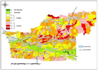
Based on the stage of land degradation and the sensitivity to desertification four categories of environmentally sensitive areas (ESAs) were found in the hilly area of Messara valley. The most widely extended ESAs areas are fragile (64.6% of the total area) (Table 11) followed by critical (25.2%), potential (9.8%) and non-threatened areas (0.4%) (Figure 29).
Figure 29: Map of environmentally sensitive areas to desertification under the existing land use and management practices in Messara valley (N=non-threatened, P=potential, F1, F2, F3=fragile, and C1, C2, C3=critical areas to desertification)

Table 11: Distribution of environmentally sensitive areas to desertification defined in the Messara valley
Fragile ESAs: Areas with mainly steep to gentle sloping slopes, and moderately fine-textured, stony in some cases, moderately deep to deep, well drained soils formed mainly on marl, shale, and conglomerates parent materials. The climate is semi-arid with rainfall greater than 510 mm, and a very dry aridity index (AI >180). These areas are mainly found on south-facing slopes, or occasionally on north-facing slopes. The dominant vegetation is olives and in some cases shrubs or phrygana, characterised by a moderate to low fire risk, moderate to high erosion protection, high resistance to drought, and vegetation cover usually greater than 75%. These areas are under moderate land use intensity and moderate enforcement of the policy for environmental protection.
Critical ESAs: Areas with very steep slopes (dominant slope >35%), and usually coarse- or fine- textured, stony, shallow to moderately deep, well drained soils formed mainly on marl, flysch or limestone parent materials, The climate is characterised as semi-arid, with rainfall greater than 510 mm, and a dry aridity index (ranging from 120-150). Areas of this subtype are mainly found on south-facing slopes. The dominant vegetation is mainly phrygana or grasses carrying a high fire risk, moderate erosion protection, and very high or high resistance to drought. Vegetation cover is usually greater than 75% or in some cases is only 25-75%. These areas are mainly under moderate land use intensity with incomplete enforcement of the policy for environmental protection.
Potential ESAs: These areas are mainly located in the valley bottom of the study area. They are nearly flat to gently sloping slopes (slope <12%). Soils are moderately fine-textured, free of rock fragments or stony, very deep, mainly well drained to imperfectly drained formed mainly on marl, conglomerates or alluvial deposits. The climate is semi-arid with rainfall greater than 510 mm, and a very dry aridity index (AI >180). These areas are usually found on north facing-slopes or they are flat. The dominant vegetation is mainly olives, and in some cases vegetables, vines or citrus. The existing vegetation is characterized by high to moderate erosion protection, mainly high resistance to drought, low fire risk and vegetation cover usually greater than 90%. These areas are mainly under moderate land use intensity and moderate enforcement of the policy on environmental protection.
Non-threatened ESAs: Non-threatened areas by desertification are confined to valleys with very deep soils, nearly flat, usually well drained, mainly free of rock fragments, formed mainly on alluvial deposits. The climate is semi-arid with rainfall 510 mm, and a very dry aridity index (AI >180). The dominant vegetation is olives or citrus characterized by low fire risk, high erosion protection, high to moderate resistance to drought, and vegetation cover usually greater than 90%. These areas are mainly under moderate land use intensity and moderate enforcement of the policy on environmental protection.
