Bio-physical description
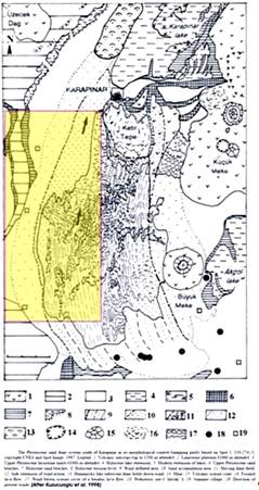
The Karapınar area comprises sediments of a Late Pleistocene shallow lake and widespread aeolian sands deposited upon a volcanic and carbonate substratum (Figure 5). Volcanic rocks are particularly widespread in the east of study site which is situated to the south of Karapınar County. Carbonate rocks are generally limestone and interbedded thin marls, and form a north-south running plateau at the midst of the study site. Sand dunes are particularly widespread in the southeast of study site over the older lake fine sediments and volcanic rocks.
Figure 5: Geological map of study site

Soils of the area are always thin (20-30 cm) lithosols. Where the sand dominates on the ground as in the case of south east areas no soil development occurs in sensu stricto, i.e. agriculture is performed directly upon loose sands. The nature of soils developed on ancient lake sediments significantly varies between organic rich loamy soils to lithosols on older sediments, but in all cases the soils are thin.
The climate is continental with a long time (1953-2006) annual average temperature of 11.5° and annual average precipitation of 285 mm. Most of the rainfall occurs in summers and autumns and is torrential in nature. A significant part of the precipitation (30% of total) falls as snow during winter months. Sand storms towards north and northeast, and to a lesser degree towards the south, can reach speeds of 110 km/h.
Vegetation cover in the area is very scarce. The only exception to this is the military area that covered by dense tree species at the centre and erosion control area to the northeast of the study site (Figure 4). High relief areas are always bare, and meadows on plateaus are weakly developed. In the last years GOs, particularly military forces and some NGOs have paid special care to reforestation activities in vicinity of Karapınar city.
The agricultural production in the study site varies from cereal and maize to sugar beet, potato and even fodders. Except for a few remnant fruit fields from previous times, no fruit plantation is encountered in the region. In the study site and its vicinity, irrigation from groundwater is a must due to very low rainfall. Flow irrigation is commonly applied and sprinkler irrigation is also widespread particularly in undulating fields. In recent years governmental subsidies and rapidly lowering groundwater levels have resulted in the encouragement of the drip irrigation practice among the farmers. In certain parts of the study site, especially in the southern villages, water supply for domestic use constitutes a series problem. Running water is always absent, and ground waters are salty. This affects the agricultural production too.
Strengths of existing land use practices are considered to be economically rewarding food production and ease of use. Since all agricultural activities are driven by unstable markets, farmers tend to produce the easiest and the most economical crop types. But adversely, these types are highly consuming in soil nutrients as well as ground water.
Under the present conditions, meadows will cease to exist due to very heavy and long-lasting overgrazing conditions. Wild species are rare, and of low coverage. The decreasing animal feeding in the last years due to unfavourable income levels provide a stop to the deterioration of meadows. The main degradation issues in the study site are soil erosion by wind due to unfavourable climatic and geologic conditions, decrease of biodiversity in meadows due to overgrazing, decreasing groundwater availability and secondary salinisation due to inappropriate irrigation techniques.