Major natural resources available in the study site area
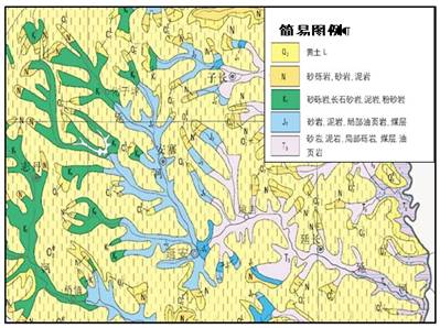
The geology in the Yanhe River Basin is fairly simple (Figure 4). Most of the area is covered by Quaternary Loess (O2). From the head to the mouth of the river, the geological layers of the surface are from sandy and muddy rock (N of Tertiary and K1of Cretaceous Period), Jurassic sandy rock and coal layer (J2) and sandy rock, muddy rock, coal layer and oil shale of Trias (T3).
The main soils in the Yanhe River basin are Mian Soil and Heilu Soil (local names). The Mian soil is distributed on slopes, terraces, alluvial land and table land. The profile has no clear difference. The Heilu soil is in the broken plateau area with clear layers. The soils here are easy to cultivate.

Figure 4: Geology of the Yanhe River Basin
It is in the semi-arid North Temperate Zone with an average annual precipitation varying from 500 to 550 mm (Figure 6), and an average annual air temperature ranging from 8.5 to 11.4°C, ≥10°accumulated temperature is 3100-3900°C, frost-free period is 180-190 days.
 |
 |
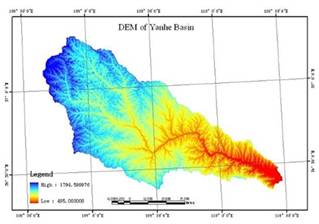
| Figure 5: DEM of Yanhe River Basin | Figure 6: Annual precipitation map |
The main vegetation systems include cropland, dam-land, paddy field, man-planting arbour forest, shrub, cash trees, orchards and grassland (Figure 7).

Figure 7: Apple orchards (left) and grass planting (right)