Fire frequency
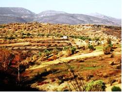
It is defined as the frequency or return time in which a fire occurs. Fire frequency adversely affects regeneration of many plant and animal communities, with some of them experiencing loss of species diversity, followed by and site degradation. For example if a pine forest destroyed by fire twice in a period of 15 years, then this species can be recovering in the burned area naturally. Forest fires are frequent in pine forest. The frequency of fire occurrence is lower in grasslands, and mixed Mediterranean macchia with evergreen forests. Pastures are frequently subjected to man-induced fires in order to renew the biomass production. Human activities are causing major disturbances to natural fire regimes around the world: by increasing the rate of fires in areas where forests seldom would burn under natural conditions (Fig. 45), by suppressing natural fires, causing ecological damage and leading to infrequent, catastrophic fires due to a build-up of inflammable material.
This indicator requires information on both historic and current fire frequency. While current fire frequency data are not difficult to collect for large areas, it is not easy to determine the historic fire frequency on a restricted forest covered area. Fire frequency shows lately an increasing trend in forest located in the vicinity of urban areas. The limits of the indicator include the difficulty in finding statistical fire data and homogeneous data on burned surfaces for different European countries, at a municipality level. Data on historic fire regimes as well as recent data have been provided by EUROSTAT and National Statistics Services. Satellite data has been also used to measure current fire frequencies through systematic registration of ignition points. The following classes have been distinguished: (a) low, ecosystem burned every 50-100 years; (b) moderate, ecosystem burned every 25-50 years; (c) high, ecosystem burned every 15-25 years; (d) very high, ecosystem burned every <15 years.


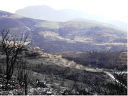
Fig. 45. Extensive areas burned in Greece in 2007 causing severe problems of soil erosion, vegetation degradation and land desertification
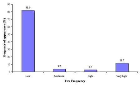
As Table 6 shows, data for fire frequency have been given for 403 study field sites, corresponding to 8 study sites. One reason for collecting comparative to other indicators few data for this indicator is attributed to the many study field sites were located in agricultural areas. Fire frequency was low (once every 50-100 years) in the majority of the study field sites, covering 81.9% of the total sites. Such fields were found in the study sites of Boteti Area-Botswana, Novij Saratov-Russia, Djanybek-Russia, Gois-Portugal, Eskisehir-Turkey, Cointzio Catchment-Mexico, and Konya Karapinar plain-Turkey (Fig. 46). Very high fire frequency has been identified in 11.7% of the study fields, corresponding mainly in the study sites of Mação- Portugal, and Boteti Area-Botswana. Moderate and high frequency (once every 25-50, 15-25 years, respectively) has been recorded in few field sites, corresponding mainly in the site of Boteti Area-Botswana (Fig. 46).

Fig. 46. Distribution of fire frequency recorded in the study field sites