Burned area
Every year, millions of hectares of the world's natural and agricultural areas are being consumed by fires, causing tremendous damage to the environment. The ecological and environmental impacts of fires are manifested by degradation of the quality of vegetation, accelerated soil erosion, loss of biodiversity, pollution of surface waters, and overall ecological retrogression. Furthermore, fires contribute to global climate change and warming. Biomass burning also results to the loss of an important sink for atmospheric carbon.
Burned area in this study has been defined as the average area burned per decade on a defined territorial surface. It is defined per decade using the annual data of natural and agricultural areas burned by wildfire, at municipality level at least. Such data have been provided by Eurostat and National Statistic Organizations. The following classes of burned area has been defined: (a) low, <10 ha of total burned area per decade on 10 km² of territorial surface; (b) moderate, 10-25 ha of total burned area per decade on 10 km² of territorial surface; (c) high, 26-50 ha of total burned area per decade on 10 km² of territorial surface; and (d) very high, >50 ha of total burned area per decade on 10 km² of territorial surface.
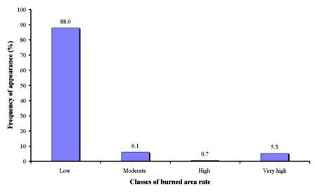
As Table 9 shows, burned area has been defined for 138 field sites, corresponding to 14 study sites. The prevailing class of burned area rate (88.0% of total study field sites) was low (<10 ha decade-1 10 km-2 of territorial surface), corresponding to Secano Interior-Chile, Boteti Area-Botswana, Konya Karapinar plain-Turkey, Santiago Island-Cape Verde, Eskisehir-Turkey, Guadalentin Basin Murcia-Spain, Novij Saratov-Russia, Djanybek-Russia, Zeuss Koutine-Tunisia, Cointzio Catchment-Mexico, Mamora Sehoul-Morocco, and Crete-Greece study sites. Moderate rate of burned area has been defined in 6.1% of the total study field sites, corresponding to Boteti Area-Botswana, and Crete-Greece study sites. Very high rate of burned area (>50 ha decade-1 10 km-2 of territorial surface) has been recorded in 5.3% of the study field sites, corresponding to Mação-Portugal study site in which the highest fire frequency has been recorded (Fig. 49).

Fig. 49. Distribution of rate of burned area identified in the study field sites