Tillage depth
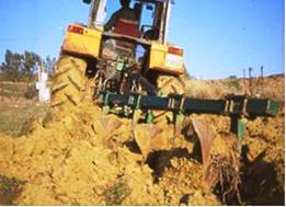
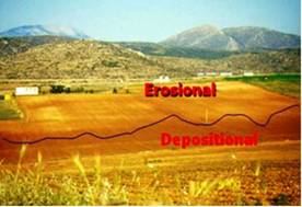
Tillage depth corresponds to the depth that tillage implements such as mouldboard plough, cultivator, chisel plough, harrow etc. are disturbing the soil. The deeper the soil is ploughed the greater the soil displacement in the direction of tillage. Studies on tillage erosion conducted during the execution of the EU research project have been shown that soil displacement was reduced to about one third when plow depth was decreased from 40 cm to 20 cm. The effect of plow depth on soil displacement is especially pronounced on steep slopes where the furrow slice with shallow plowing sometimes do not completely turn but it remains in an angle usually perpendicular to the soil surface, so that soil displacement is greatly reduced (Fig. 61). When furrow slice is reversed in the down or up slope direction (independently of tractor travel direction), soil displacement is greater because gravity acts as an additional force displacing farther the soil. Of course other parameters besides plowing depth and slope gradient could affect reversion and breaking down of furrow such as tractor speed, soil moisture content, soil consistence, rock fragment content, etc.
Tillage depth has been defined by conducting the land user or the extension services of the related institutes. Also plough depth was easily to measure in the field by digging the upper soil layer and measuring the depth in which tillage implements reach. The following classes have been defined: (a) shallow, tillage depth <20 cm; (b) moderate deep, tillage depth 20-30 cm; (c) deep, tillage depth 30-40 cm; and (d) very deep, tillage depth >40 cm.


Fig. 61. Displacement of soil to the direction of ploughing accompany with reversion of plough slice due to the deep ploughing (left) and displacing huge amounts of soils from the upper convex and linear part of the slope and depositing in the lower concave part (right)
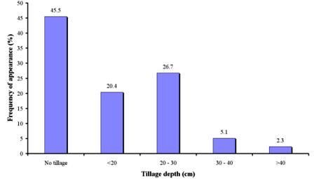
As Table 8 shows, data on tillage depth have been collected in 1040 study field sites, corresponding to 13 study sites. As Fig. 61 shows, the dominant class of tillage depth is 20-30 cm covering 26.7% of the study field sites. Such tillage operation has been mainly found in the study sites of Secano Interior-Chile, Rendina Basin Basilicata-Italy, Boteti Area-Botswana, and Konya Karapinar plain-Turkey, Sehoul-Morocco, Eskisehir-Turkey, Cointzio Catchment-Mexico, Guadalentin Basin Murcia-Spain, and Crete-Greece. The next important class of tillage depth was less than 20 cm, covering 20.4% of the total fields, and corresponding mainly to the study sites of Secano Interior-Chile, Rendina Basin Basilicata-Italy, Santiago Island-Cape Verde, Mamora Sehoul-Morocco, Zeuss Koutine-Tunisia, and Crete-Greece. Deep (30-40 cm) and very deep (>40 cm) plowing has been defined in few cases, covering 5.1% and 2.3% of the study field sites. Such cases of deep plowing have been described in the study sites of Rendina Basin Basilicata-Italy, Novij Saratov-Russia, and Loess Plateau-China. Finally, the dominant class was no tillage operations, covering 45.5% (Fig. 61) of the total fields, with all the positive effects on soil quality and soil erosion protection. Such type of land management has been found in the study sites of Secano Interior-Chile, Rendina Basin Basilicata-Italy, Santiago Island-Cape Verde, Mamora Sehoul-Morocco, Zeuss Koutine-Tunisia, Guadalentin Basin Murcia-Spain, Loess Plateau-China, Eskisehir-Turkey, Konya Karapinar plain-Turkey, Boteti Area-Botswana, and Crete-Greece. In conclusion, tillage operations are mainly conducted in relatively shallow depths or no tillage operations are applied, reducing significantly tillage erosion and land degradation in the study field sites.

Fig. 61. Distribution of tillage depth classes defined in the study field sites