Land use intensity
Land use intensity is referred to all types of land uses, agriculture, pastures, forests, etc. Land use intensity in cropland areas is related to the degree in which the cultivation of the land is mechanized, the application or not of fertilizers and pesticides, and finally the use of water for irrigation (Fig 82). Repeated cultivation of soils associated with other management practices (application of herbicides and pesticides) results in decreased organic matter content and aggregate stability favouring soil crusting, overland flow, and erosion. Soil compaction is also another form of soil degradation resulting from heavy machineries used in agricultural areas. In pastures, land use intensity is related to the number of animals grazing the land compared to the sustainable number of animals based on the amount of biomass production (Fig. 82). Intensive grazing results in loss of vegetation cover, degradation of soil structure due to animal trampling, favouring overland flow, and soil erosion.
Land use intensity in forested areas is related to yields in wood extraction compared to the sustainable wood extraction. In case that trees are removed in rate higher than the sustainable number stand density decreases gradually, then the soil is partially covered with vegetation and therefore from raindrop impact and soil erosion. In mining areas soils are usually disturbed with the bedrock or waste materials exposed in the surface. Such areas require rehabilitation by transporting and spreading soil for allowing the native vegetation to grow.
Recreation areas can be subjected to high number of visitors in certain period affecting soil surface in certain pathways. Some of the effects of many people walking in such areas are: destruction of annual vegetation, disturbance of soil aggregates, formation of pathways in which runoff water can concentrate and generating mainly gully erosion.


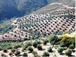
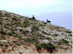
Fig. 82. Examples of intensive land use of agriculture area (left) and pasture (right)
Three classes of land use intensity are distinguished to: (a) low, (b) medium, and (c) high. The definition of each class is based on the type of land use. For each of the following land use types, the intensity of the use is assessed separately based on the MEDALUS III methodology:
- Agricultural land (cropland, pasture or rangeland)
- Natural areas (forests, shrubland, bare land)
- Mining land (quarries, mines, etc.)
- Recreation areas (parks, compact tourism development, tourist areas, etc.).
The land use intensity for cropland has been assessed by characterizing the frequency of irrigation, degree of mechanization, the use of agrochemicals and fertilizers, the crop varieties used, etc. Three levels of land use intensity are distinguished for the agricultural areas as following:
- Low land use intensity (extensive agriculture): Local rain fed plant varieties are used, fertilizers and pesticides are not applied, yields depend primarily on the fertility of soils and environmental conditions. Mechanization is limited. In the case of seasonal crops, one crop is cultivated per year or the land remains fallow.
- Medium land use intensity: Improved varieties are used, insufficient fertilizers are applied and inadequate disease control is undertaken. Mechanization is restricted to the most important tasks such as sowing.
- High land use intensity (intensive agriculture): Improved varieties are used. Application of fertilizers and control of diseases are adequate. Cultivation is highly mechanized.
The land use intensity for pasture land has been assessed by estimating the grazing capacity (GC) of the area and comparing it with the stocking rate (SR). The necessary formulas for assessing these values are given in the indicator "grazing intensity". The intensity of use has been estimated by comparing the GC and the actual number of animals grazing the land (SR) and forming the ratio actual/sustainable. The following classes have been distinguished: (a) low (SR<GC), (b) moderate (SR = GC to 1.5*GC), and (c) high (SR>1.5*GC).
The assessment of land use intensity for natural land (forests) requires a major distinction between natural forests and managed forest. In the case of natural forests the land use intensity is considered low as there is by definition absence of any management. In the case of managed forests, the intensity of use has been determined by comparing the sustainable (S) and the actual (A) yield of the forest and forming the ratio actual/sustainable. The following classes are distinguished: (a) low (A/S = 0), (b) moderate (A/S <1), and (c) high (A/S = 1 or greater).
Mining activities have a highly degrading effect both during their lifetime and after the end of the mining. Hence, a primary distinction is made between active and inactive mining sites. For active site, the intensity of land use has been assessed as following: surface or subsurface mining with full rehabilitation and erosion monitoring and control will be considered as well managed (low land use intensity). Surface or subsurface mining with moderate rehabilitation and erosion monitoring and control will be rated with medium land use intensity. Surface or subsurface mining activities without rehabilitation and with minimum erosion monitoring, will be rated with high land use intensity.
The assessment of land use intensity in recreation areas requires the basic distinction between passive and active recreation, since these may cause a significant variation on the degree of stress on the land. Passive recreation, which is the least threatening to the environment, includes walking, nature seeing, mountain climbing, swimming and similar activities. Active recreation, which is more important for land degradation includes: skiing, cross country skiing games, sand rallies, motor racing etc. The assessment procedure has considered: (a) assessment of the visitor carrying capacity of the recreation area (maximum number of visitors permitted per year), (b) assessment of the actual number of visitors per year, (c) calculation of the ratio of actual to permitted number of visitors per year, (d) rating the quality of management as high if the ratio is equal or less than one, and as low if the ratio is greater than one.
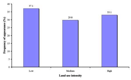
Data for the indicator "land use intensity" have been collected in 1258 study field sites, corresponding to 16 study sites (Table 11). As Fig. 83 shows, low land use intensity was the next important class, covering 37.1% of the study field sites, and corresponding to study sites of Boteti Area-Botswana, Secano Interior-Chile, Rendina Basin Basilicata-Italy, Santiago Island-Cape Verde, Mamora Sehoul-Morocco, Zeuss Koutine-Tunisia, Eskisehir-Turkey, Gois-Portugal, Cointzio Catchment-Mexico, Mação- Portugal, Loess Plateau, China, and Crete-Greece. High land use intensity has been identified in 33.1% of the study field sites, corresponding to the all cases of the study sites of Novij Saratov-Russia, Djanybek-Russia, and Konya Karapinar plain-Turkey, and in some cases in the study sites of Boteti Area-Botswana, Secano Interior-Chile, Rendina Basin Basilicata-Italy, Santiago Island-Cape Verde, Zeuss Koutine-Tunisia, Eskisehir-Turkey, and Crete-Greece. Finally, medium land use intensity has been identified in 29.8% of the study field sites, corresponding to all sites of Guadalentin Basin Murcia-Spain, and in some cases in the study sites of Boteti Area-Botswana, Cointzio Catchment-Mexico, Gois-Portugal, Novij Saratov-Russia, Secano Interior-Chile, Rendina Basin Basilicata-Italy, Santiago Island-Cape Verde, Mamora Sehoul-Morocco, Zeuss Koutine-Tunisia, Mação- Portugal, Loess Plateau, China, and Crete-Greece.

Fig. 83. Distribution of land use intensity classes identified in the study field sites