Period of existing land use
The present land use type, and the period of existence of that land use type, is an important indicator as it is related to cumulative long effects on land protection or on land degradation. The vegetation patterns which cover the landscape affect the soil in all its dynamics, including water redistribution over and within the soil, soil erosion, soil organic matter content, microbiological activity, etc. Of course other factors such as land use intensity, climate, topography, etc. have a variable effect on soil degradation. Long term experimental soil erosion studies conducted along the northern Mediterranean Europe under various land uses and exiting land management practices have shown the following average sediment loss range of soil erosion rates (Kosmas et al., 1997):
- Cereals: 15- 90 t km-2 yr-1
- Vines: 67- 460 t km-2 yr-1
- Eucalyptus: 1.4-65.6 t km-2 yr-1
- Olives: nill-5.3 t km-2 yr-1
- Shrubland: 0.5-13.8 t km-2 yr-1.
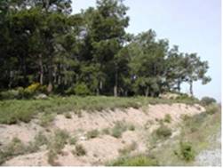
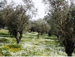
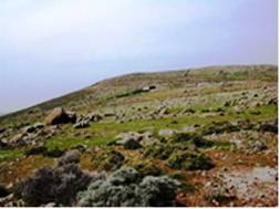
Therefore, land use type over a long period is clearly an important factor in controlling soil loss and desertification risk. As Fig. 84 shows, land use had a great effect on soil erosion and land degradation under pine forest, olive groves, and cereals replaced as grazing land after severe soil degradation in the island of Lesvos (Marathaniou et al., 2000). Clearing of pine forest and replacement with olive groves had no significant effect on land degradation. On the contrary, clearing of pine forest and replacing with cereals or grazed without applying sufficient measures for soil protection, land had largely degraded and desertified, with the present soil being unable to support adequate vegetation cover.


Fig 84. Typical example of long term effect of land use on land degradation under the same soil, topographic, and climatic conditions in which part of the pine forest (left) was cleared and replaced by olive grove (middle), and cereals followed by pasture (right)
The following 5 classes of period of land use have been defined for the purpose of this project: (a) period <5 years, (b) period 5-10 years, (c) period 10-20 years, (d) period 20-50 years, and (e) period >50 years. The period of existing land use has been defined by contacting the land user or by interpretation of a chronological series of aerial photographs.
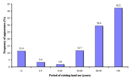
As Table 11 shows, periods of land use have been defined in 1206 field sites, corresponding to 13 study sites. The prevailing period of existing land use was greater than 50 years, covering 42.2% of the study sites, corresponding to the study sites of Boteti Area-Botswana, Santiago Island-Cape Verde, Mamora Sehoul-Morocco, Cointzio Catchment-Mexico, Zeuss Koutine-Tunisia, Guadalentin Basin Murcia-Spain, and Crete-Greece (Fig. 85). The next important period class of existing land use was 20-50 years, covering 29.4% of the study field sites, corresponding to the study sites of Boteti Area-Botswana, Novij Saratov-Russia, Djanybek-Russia, Secano Interior-Chile, Nestos Basin Maggana-Greece, Mamora Sehoul-Morocco, Guadalentin Basin Murcia-Spain, Zeuss Koutine-Tunisia, and Crete-Greece. The period of 10-20 years of existing land use has been defined in 11.7% of the study field sites, corresponding to the study sites of Boteti Area-Botswana, Djanybek-Russia, Secano Interior-Chile, Santiago Island-Cape Verde, Mamora Sehoul-Morocco, Guadalentin Basin Murcia-Spain, Zeuss Koutine-Tunisia, and Crete-Greece. A very short period of exiting land use (less than 1 year) has been identified in 11.4% of the study field sites, corresponding to the study sites of Novij Saratov-Russia, Eskisehir-Turkey, and Konya Karapinar plain-Turkey. The other period classes of existing land uses 1-5, and 5-10 years were identified in few cases, covering 3.7%, and 1.9% of the study field sites, respectively, and corresponding to the study sites of Novij Saratov-Russia, Secano Interior-Chile, Mamora Sehoul-Morocco, Guadalentin Basin Murcia-Spain, and Crete-Greece.

Fig. 85. Distribution of period of existing land use classes identified in the study field sites