Runoff water storage
Surface water Runoff is the most important direct driver of soil erosion in hilly areas. There are many factors and processes affecting water runoff such as vegetation density, biological activity, soil crusting, micro-topography, soil texture and structure, plant cover, rainfall amount and intensity, slope gradient land management practices, etc. The degree of crusting of soil surface has a strong influence on infiltration rates and therefore surface water runoff rates. Micro-topography of the soil surface consisting of random roughness on the surface, together with cultivation features such as plough ridges retards water flow and increases amount of water infiltrating into the soil.
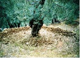
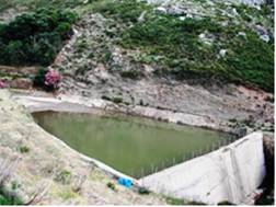
Runoff water storage is defined as the volume of runoff water stored into the soil or in small ponds. Storage of water runoff is defined in terms of land management for reducing surface water runoff and increasing soil infiltration rates. For example, presence of adequate shrubby or annual vegetation cover, high biological activity, construction of terraces, shallow ploughing of the soil parallel to the contour lines, concentrating the runoff water in small ponds and retarding runoff, keeping plant residues on the soil surface, etc. are some practices for runoff water storage (Fig. 90a). Measurement of the indicator is based on self-assessment subject to personal judgement if existing management practices for runoff water storage are applied, and how efficient they are for the study field site. The following classes have been distinguished: (a) no actions for runoff water storage, (b) low actions for runoff water storage, (c) moderate actions for runoff water storage, and (d) adequate actions for runoff water storage.


Fig. 90a. Typical examples of surface water runoff storage small ponds constructed around the tree and concentrating the nearby the tree runoff (left) or on a water way storing runoff from larger area (right)
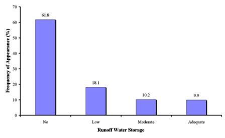
Data for this indicator have been defined for 1054 study sites, corresponding to 12 study sites (Table 12). As Fig 90b shows, no runoff water storage actions have been identified in the majority of the study field sites, covering 61.8% of the total field sites. Such land management practices has been found in all study field sites of Novij Saratov-Russia, Djanybek-Russia, Guadalentin Basin Murcia-Spain, Eskisehir-Turkey, and Konya Karapinar plain-Turkey sites, and in some field sites of Boteti Area-Botswana, Djanybek-Russia, Santiago Island-Cape Verde, Mamora Sehoul-Morocco, Zeuss Koutine-Tunisia, Cointzio Catchment-Mexico, and Crete-Greece. Low actions of surface water runoff storage was the next important class, covering 18.1% of the study field sites, and corresponding to few cases in the study sites of Boteti Area-Botswana, Djanybek-Russia, Santiago Island-Cape Verde, Zeuss Koutine-Tunisia, Cointzio Catchment-Mexico, and Crete-Greece. Adequate actions of surface water runoff storage have been defined in 9.9% of the study field sites, corresponding to some cases of the study sites of Boteti Area-Botswana, Santiago Island-Cape Verde, Mamora Sehoul-Morocco, Zeuss Koutine-Tunisia, and Crete-Greece. Finally, moderate actions of surface water runoff storage has been identified in 10.2% of the study field sites, corresponding to few cases in the study field sites of Boteti Area-Botswana, Cointzio Catchment-Mexico, Santiago Island-Cape Verde, Mamora Sehoul-Morocco, Zeuss Koutine-Tunisia, and Crete-Greece.

Fig. 90b. Distribution of runoff water storage classes defined in the study field sites