Home Cointzio, Mexico Crop rotation and minimum tillage: experimental results and conclusions

Crop rotation and minimum tillage: experimental results and conclusions Print

In the Cointzio basin, land degradation is mainly due to free grazing of cows. To avoid this, a global solution must be searched and must be adapted to different environmental situations. Due to the critical economic situation of farmers, men and women can act only with subsidies (local projects), managed by political authorities.
The Cointzio basin has different kinds of soil erosion due to the type of climate (temperate semi-humid with a 6 months rainy season), soils and geomorphology as well as land uses (some mechanized farming, mainly rainfed agriculture with free grazing cattle, forest, recent avocado plantations). Apart from the land degradation, the downstream effect is the refilling of the Cointzio dam used for drinking water of the capital of Michoacán, as well as occasional severe flooding. One of the techniques tested is the effect of crop rotation, including minimum tillage, on sediment losses.


Experiment with the use of crop rotation systems to combat erosion

Different rotation systems were tested on plot level during 5 years on 8 erosion plots at 2 sites (Acrisol and Cambisol andic) with traditional corn/ fallow/corn with organic fertilization and corn or cereal with no tillage and crop residues. Climate, soil and water erosion, soil properties and agronomical parameters were surveyed. Measurements included were:

  • Agro-meteorological data was registered in the field (La Cortina watershed) at every 30 minutes for temperature (max, min), wind (speed direction), humidity and UV solar radiation. Rain was recorded in 3 places (La Cortina, La Cienega, Potrerillos which are own catchments followed) by tipping bucket method (every 0.2 cc with a second precision) from which rain volume, intensity, kinetic energy and erosivity were calculated. Historical agro-meteorological data from of 5 meteo-stations in the Cointzio catchment were also used.
  • Runoff was measured (1 min registration and 1 mm precision) in 3 sub-catchments and also at the outlet of the Cointzio catchment for 5 years.
  • Sediment traps were designed and installed in the 3 small catchments. The sediment samples are collected after every rainfall event. In the case of the basin outlet, suspended sediment concentration was assessed from the turbidity.
  • Infiltration was measured in andosols and in acrisols with 4 kind of treatments (natural-forest; ploughed, lower part of furrows one year after corn cultivation and higher part of furrows also one year after corn cultivation).


Results

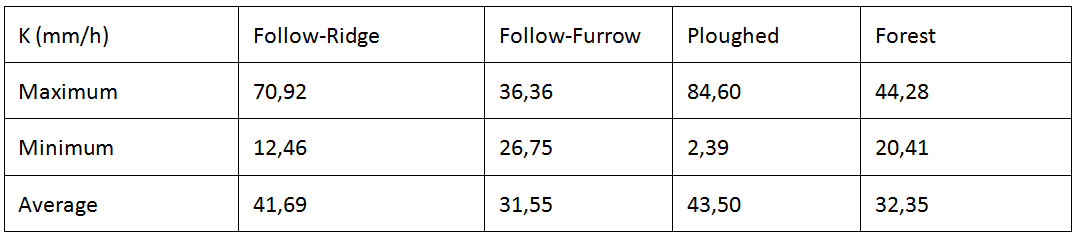
The effect of crop rotation on infiltration, runoff generation and sediment production were tested. The discharge from the Cortina and Potrerillos watershed in 2010 seems to have nearly the same values (4 and 6 m³ s-¹). The discharge from the Huertitas sub-watershed was a little lower than the other two. Since this catchment is 3 times smaller than the other catchments the Heurtitas sub-watershed can be considered more degraded.

Infiltration measurements show that it is very high in Andisols as compared to the Acrisols (3 mm/h). Crop rotation seems to have not much effect in infiltration rates. But, it can have differences within the same crop rotation system, for example infiltration on the ridge of the furrows and at the lower parts can be very different. This variation must be taken into count in the modeling and interpretation of runoff and soil erosion.

Hydraulic conductivity obtained in the Andic Cambisol of sub-watershed of La Cortina (Y. Grusson, 2010)

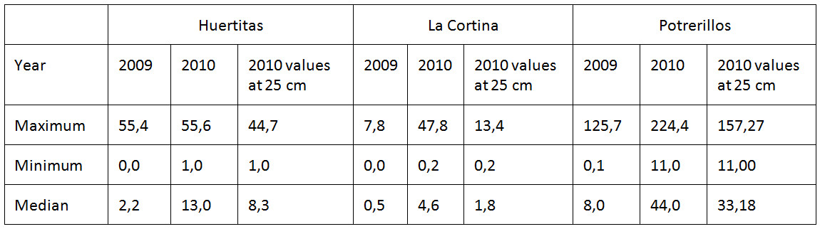
Rainfall was nearly 50% higher in in 2010 as compared to 2009 which resulted in higher sediment concentration with the highest concentration in the sub-watershed of Poterillos.

Comparison of maximum, minimum and median sediment concentration in the 3 catchments (Y. Grusson, 2010)

The two catchments generated high sediment yields (Huertitas, 900–1500 t km−² y−¹; and Potrerillos, 600–800 t km−² y−¹). The sub-watershed of La Cortina generated a rather low sediment (30 t km−² y−¹). At the scale of the entire Cointzio basin (630 km²), it was not possible to derive any direct relationship between rainfall intensity and sediment concentration. This can be explained by the high spatial variability of rainfall and due to vegetation growth throughout the season. Erodible sediment availability on hill slopes was identified as the main factor controlling suspended sediment delivery. The occurrences of numerous active gullies in Huertitas and Potrerillos provided a constant sediment source linked to the river network, which explains the high SSY recorded at both stations. At the sub-watershed scale, a combination of various parameters was responsible for sediment control. Peak discharges during floods were found to be significantly associated with exported loads; discharge proved to be a controlling factor when sediment was not lacking.


How well does it work?

 No evaluation results were given so this analysis cannot be done.


Stakeholders' opinions

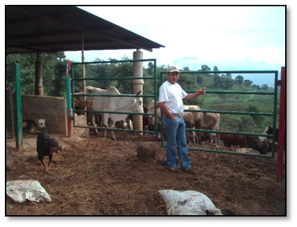
The agro-climatic measuring instruments, rain gauges, water level and sediment trap installation were located in the farmer's fields. The farmers took care of the instrument and in some case, they also helped to take samples, and do some measurements. As the farmers were paid, they were interested. But they don't see a direct interest for themselves because our results are interesting at a watershed scale and not really at individual farm level. If the regional authorities want to stop sedimentation of the dam, an integrated policy is needed.


Conclusions

Minimum tillage, good ground cover, fertilization and organic residue incorporation are the key solutions to reduce soil erosion.
To control free cattle grazing, the economic situation of the farmers has to be taken into account.
Farmers involvement is possible if program brings money to do concrete actions.


More details ...
»Field experiment results and conclusions in all study sites


assess_1.jpg.jpg

Acknowledgement

fp6 logo 3 50 x 43
The DESIRE project was 
co-funded by the
European Commission,
Global Change and
Ecosystem.
DESIRE brought together the expertise of
26 international research institutes
and non-governmental organisations.
This website does not necessarily
represent the opinion of the
European Commission. The European
Commission is not responsible for
any use that might be made of the
information contained herein.

Follow us