|
Evaluating the desertification risk assessment tool with local experimental results |
 |
|
Author: Victor Jetten
Introduction
In the Cointzio basin, land degradation is mainly due to free grazing of cows. To avoid this, a global solution must be searched and must be adapted to different environmental situations. Due to the critical economic situation of farmers, men and women can act only with subsidies (local projects), managed by political authorities. The Cointzio basin has different kinds of soil erosion due to the type of climate (temperate semi-humid with a 6 months rainy season), soils and geomorphology as well as land uses (some mechanized farming, mainly rainfed agriculture with free grazing cattle, forest, recent avocado plantations). Apart from the land degradation, the downstream effect is the refilling of the Cointzio dam used for drinking water of the capital of Michoacán, as well as occasional severe flooding. One of the techniques tested is the effect of crop rotation, including minimum tillage, on sediment losses.
Desertification indices
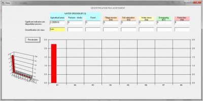
The desertification risk calculated is water erosion. The calculated risk is moderate (2.58). Introducing a rotation system will presumably increase the soil cover which is an option in the tool. This lowers the risk to low (2.37) while the minimum tillage further reduces the risk to (2.25).

Conclusions
The desertificatio risk assessment tool correctly identifies the risk for water erosion in this area and the effect of the mitigation measures.
|


