Home  Sehoul, Morocco Land degradation and conservation maps
| Land degradation and conservation maps |
 |
|
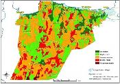
The WOCAT tool for mapping land degradation and sustainable land management has been used in the Sehoul study site. Using the tool, an interdisciplinary team of specialists has recorded observations of land degradation, sustainable land management and recommendations for further prevention or mitigation on a land use base map.
Map version: 4Oct11
|
Study sites
Acknowledgement
The DESIRE project was
|
DESIRE brought together the expertise of
26 international research institutes
and non-governmental organisations.
This website does not necessarily
represent the opinion of the
European Commission. The European
Commission is not responsible for
any use that might be made of the
information contained herein.