Home 1. Study site contexts & goals Mapping desertification extent

Mapping desertification extent

Assessment and mapping of the extent of sustainable land management in the DESIRE study sites.

Godert van Lynden


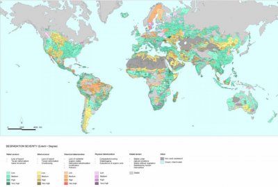
Global investments in soil and water conservation (SWC) have been huge in the past century, yet a clear overview of their extent and effectiveness is lacking. Information on past experiences is scattered and therefore hardly benefiting new SWC activities. Since 1992 the World Overview of Conservation Approaches and Technologies ( WOCAT ) programme is filling in this gap by using a standardised methodology to document and evaluate case studies of SWC worldwide and assess their spatial extent. SWC in this context should be interpreted broadly synonymously with sustainable land management (SLM). An Overview Book ( "Where the land is greener") was launched in 2007, presenting about 40 case studies from around the world. In the DESIRE project Research Theme 3 is coordinating the documentation of case studies within the DESIRE study sites.


 While maps of soil and land degradation exist at national or regional level - the only global overview so far remains the  GLASOD map by ISRIC and UNEP from 1991 - maps on the extent of soil and water conservation or sustainable land management seems to be almost completely lacking. Therefore policy makers and implementing institutions do not and cannot have a good spatial overview of their and others' past and ongoing activities.


In close collaboration with the FAO-Land Degradation in Dryland Areas (LADA) project and WOCAT, DESIRE is taking a first step to fill this gap by using WOCAT's method of sustainable land management mapping for each of the study site areas.


More details ... land degradation and conservation maps for each study site

»Guadalentín, Spain
»Mação, Portugal
»Góis, Portugal
»Rendina, Italy
»Crete, Greece
»Nestos River Delta, Greece
»Karapinar, Turkey
»Eskişehir, Turkey
»Sehoul, Morocco

»Zeuss Koutine, Tunisia
»Dzhanibek, Russia
»Novy, Russia
»Yan River Delta, China
»Boteti, Botswana
»Cointzio, Mexico
»Secano Interior, Chile
»Ribeira Seca, Cape Verde
# Article Title
1 WOCAT tool for mapping land degradation and land conservation
2 Spatial extent of degradation and conservation in DESIRE study sites
 
BOteti_DESIRE_Wocat_workshop__R_Chanda_.jpg.jpg

Acknowledgement

fp6 logo 3 50 x 43
The DESIRE project was 
co-funded by the
European Commission,
Global Change and
Ecosystem.
DESIRE brought together the expertise of
26 international research institutes
and non-governmental organisations.
This website does not necessarily
represent the opinion of the
European Commission. The European
Commission is not responsible for
any use that might be made of the
information contained herein.

Follow us