|
Evaluating the desertification risk assessment tool with local experimental results |
 |
|
Author: Victor Jetten
Introduction
On the Loess plateau area in the Yan River Basin in China, severe soil erosion is common. This results in deep gully and badland formation on the steeper slopes. To rehabilitate gullies, check dams have been constructed. These limit runoff and sediment delivery downstream and increase water availability for maize. The slopes can be stabilized with terrace constructions. Because of annual rainfall fluctuates between 400 and 1100 mm (average 560 mm), water can be a limiting factor in this region. Soil water conditions are monitored and compared to crops on the slopes, as well as runoff and erosion under different land uses. The erosion is especially important downstream while the conservation measures are tought to be important on site (because of soil moisture increase).
Desertification indices
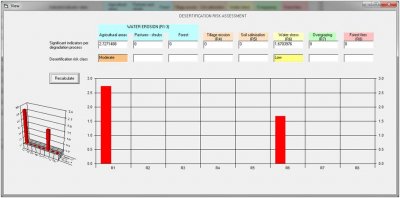
The main desertification process is water erosion and secondary is water stress, because of erosive soils (loess) and occasional heavy rainfall. Erosion risk is classified as moderate (2.72) in spite of the very steep slope and bare soil and absence of conservation measures. Water stress is classified as low (1.67) probably because of the absence of a direct link between amount of rainfall and water stress in the desertification risk assessment tool.
Applying a terraced situation results in a slight lowering of the water erosion risk which is starnge because apart from choosing terraces as conservation the slope is set to < 2%. The water stress is correctly lowered to “no risk” (1.32).
 |
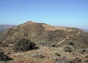
Bare area on steep slopes with loess soils |
Conclusion
The water erosion react counter intuitively to a lowering of the slope from >35% to < 2% with hardly and change, while the water stress is correctly reduced considerably.
|


