|
Fire strip network: experimental results and conclusions |
 |
|
Like many Mediterranean countries Portugal suffers from forest fire due to its dry and hot climate. The problem is not only degradation of forest and the emission of carbon dioxide to the atmosphere but it also increases soil losses and pollution of water and air. The Mação Region in Portugal suffered massive fires in 2003 and 2005 affecting more than 70% of the municipality area. To protect the forest from wild fire strip network is constructed. This can have negative impact by increasing surface runoff and soil losses due to the removal of vegetation along the strips. An experiment was carried out to study runoff and sediment loss from different tree species.
Experiments with fire corridors for protection
|
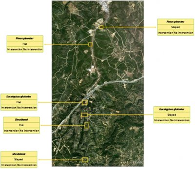 |
Forest is the dominant land use in the Mação Region in Portugal, which consist dominantly of Pinus pinaster, with some Eucalyptus globulus trees. Preventive forestry is composed of a set of measures applied to forest stands, shrubs and other spontaneous species to protect against fires. These measures deal with forest stands composition, structure and location, aiming to reduce fire risk and to increase vegetation resilience to fire but the removal of vegetation tends to expose bare soil to the erosive effects of rainfall. |
| Rainfall simulators were used to assess erosion processes. Considering the intensity of the extreme rainfall of the area the rain simulators were adjusted to intensity of 45 mm/h. Run off and suspended sediments were measured from a plot of size a 0.26 m2 located in the center of the target areas. |
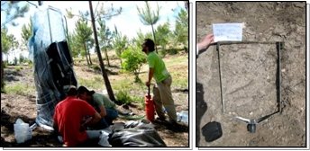 |
All the measurements have 3 replications. They were carried out in all the plant species (table below). In addition soil samples were collected for analysis of texture, soil moisture and organic matter content.

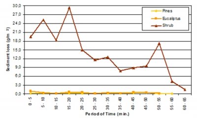
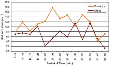
- Rainfall simulations in flat Shrubland and sloped Eucalyptus sites resulted on the highest cumulative sediment losses; Shrubland did not have vegetation cover and Eucalyptus is located on a stony ground (>90%).
- Flat Eucalyptus and Pine sites led to insignificant soil losses.
- The influence of slope only had a significant impact in Eucalyptus sites.
- Sediment loss on flat Shrubland was higher than on sloped Shrubland.
- There was small variation of sediment loss on flat Pine and Eucalyptus sites throughout rainfall simulations.
- Sediment loss on flat Shrubland site was higher in the first 20 min but decreased significantly until the end of the simulations; the presence of high peaks may be explained by micro relief water accumulation.
- No runoff on sloped Pine sites was registered (Figure 5); there was higher variation of sediment loss during rainfall simulations both on sloped Shrubland and on Eucalyptus sites.
 |
 |
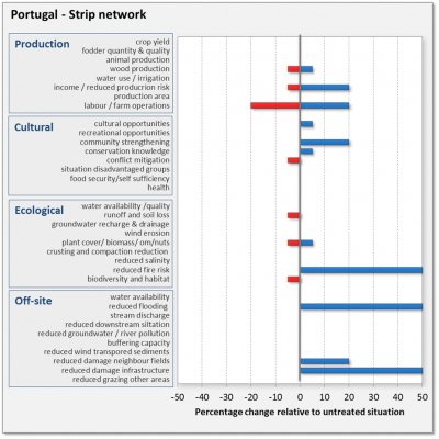 |
The results are evaluated from a production, socio-cultural and economic point of view. The bars express the estimated or measured percentage of change with respect to the reference situation. This change can be positive (blue) or negative (red). Note that this evaluation is based on the experiments, on the long term experience of the coordinating team in this area and on consultations with the farmers. |
- Field work in close collaboration between researchers and local technicians from GTF (Forestry Technical Office of the Municipality of Mação) and Aflomação (Forestry Association of Mação) – selection and assessment of field-test areas.
- Increase knowledge among researchers and local stakeholders about the effects of the mitigation strips technology on soil erosion and/or conservation.
- Promotion of future opportunities for dissemination and further developments under the suitability of this technology.
- Due to high implementation and maintenance costs, this technology requires the full support from public entities (as well as specific technology capacity).
| Forest fire prevention using strip network is a useful technique but it can cause increased runoff and soil losses since the area along the strips will be bare and exposed to erosive rain. Villagers were very interested in the technique and will attempt to maintain the strips themselves. Currently the main infrastructure is protected but not the side roads. Possibly the stripnet work will extend to those ass well. Where trees are cut at the strip there is a risk of erosion. Sediment loss from the strip area depends on tree species and terrain slope gradient. The erosion risk appears to be relatively low. Due to the testing activities, the erosion risk is now better integrated into thestrip construction. |
|

