|
Evaluating the desertification risk assessment tool with local experimental results |
 |
|
Author: Victor Jetten
Introduction
The Novy study site covering the Marksovsky Region of Saratov Oblast is situated at left bank of Volga River, and has a semi-arid climate. A long warm and dry summer with little rainfall every second year makes an extensive rainfall based agriculture practically impossible. Considerable land use changes have taken place over the last 40 years while first large irrigation system been constructed based on sprinkler irrigation use. This has caused regional ground water rising and secondary salinization appearing, as well as of developing of zones suffering of local runoff and water erosion by excessive irrigation. The collapse of the Soviet Union and increased socio-economic crises with rising prices of energy (pumping water from the Volga river), the use of irrigated land at Marksovsky Region diminished more than 5 times from its original size. Sprinkler irrigation was partly replaced by furrow irrigation, which is less expensive (no pumping) but has a low efficiency. as much water is lost because of low infiltration rates. This in fact generates soil erosion in the furrows and sedimentation of agrochemicals in nearby ponds. Drip irrigation has a much better controlled application of water below the surface, which conserves water and prevents erosion.
Desertification indices
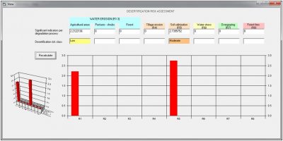
The main desertification process is salinization and water erosion because of excessive irrigation. The salinization risk is calculated as low (2.39) which correctly reflects the situation as the irrigation water source is fresh river water. On very poorly drained soil this risk may become moderate (2.68). The erosion risk is calculated as low (2.21) which is logical because excessive irrigation is not a factor in the system and the natural rainfall would not cause erosion.
 |
Erosion and Salinization risk and onvery poorly drained soils
|
Conclusion
The desertification risk assessment tool correctly identifies the salinization risk but cannot calculate the man-made erosion risk which is logical.
|


