Home Sehoul, Morocco Evaluating the desertification risk assessment tool with local experimental results

Evaluating the desertification risk assessment tool with local experimental results Print

Author: Victor Jetten


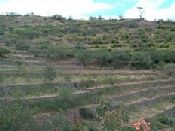
Introduction

The north west of Morocco has areas with extensive gullying of the agricultural lands. High pressure agriculture and overgrazing, combined with occasional heavy rainfall, causes severe land degradation. An additional problem is sedimentation in the drink water reservoirs downstream. For farmers in the area, annual crops for food production and livestock for immediate income is vital. The area characterized by a strong variation in seasonal rainfall from year to year. Ploughing is done at the first rains after September and with sufficient rainfall there will be a moderate harvest in February (mostly Wheat and Barley). If the crop fails it is used for fodder. For farmers in the area, annual rainfed crops for food production and livestock for immediate income is vital. There are no additional water sources and water conservation measures could help in this situation.


Desertification indices
The first area is abandoned and has heavy gully incision but analysis with high resolution remote sensing of gully change actually sows that the current erosion is not so high. This is well reflected in the erosion risk index of 2.92 (moderate risk). Vegetation cover is annual herbs and grasses. Water stress is seen as no risk (1.29) and there is a low risk of over grazing (2.38). The technique of gully stabilization with planting of Atriplex bushes and fencing cannot be tested directly but the added effect of an increase in cover and biomass can be simulated, while there is an assumed moderately effective capturing of runoff. Implementing this leads to a water erosion risk of 2.49 (low risk). Overgrazing reduces to low risk (1.62).


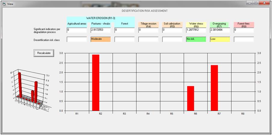
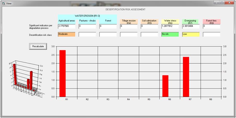
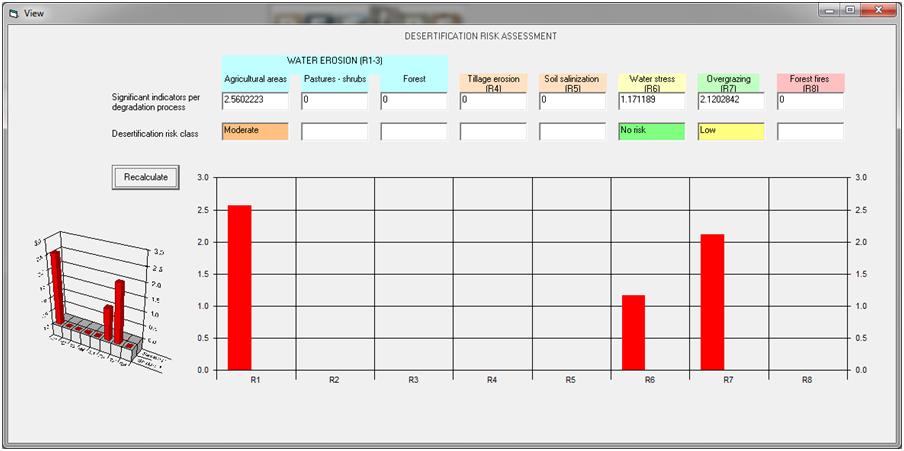
The second technique is minimum tillage on a rainfed cereal producing field on stony shallow soils. The slope angle is the same (20%). Under unmitigated circumstances the water erosion risk is moderate (2.78), a low overgrazing risk (2.38) and no water stress risk (1.29). Applying minimum tillage slightly lowers the erosion risk (still moderate: 2.56) and lowers also the water stress (1.17) and overgrazing risk (2.12).


Abandoned  land (herbs/grass) on steep gullied slopes unmitigated Implementing gully control by planting bushes and fencing
Cereals on steep slopes, unmitigated Cereals, minimum tillage


Conclusions
The desertification risk assessment tool correctly classifies the risk levels of water erosion and overgrazing, but seems to underestimate the water stress risk (farmers have a difficult time gaining sufficient yield from rainfed agriculture in the area). The results are in line with the experimental results. Also when implementing the techniques the results are adequate although less pronounced than the experimental results. The techniques have to be translated to a change in primary variables first for this to happen (e.g. fencing means an increase in cover).


More details ... general conclusions and results from other study sites
»Evaluating the Desertification Risk Assessment Tool with experimental results


fig10f.jpg.jpg

Acknowledgement

fp6 logo 3 50 x 43
The DESIRE project was 
co-funded by the
European Commission,
Global Change and
Ecosystem.
DESIRE brought together the expertise of
26 international research institutes
and non-governmental organisations.
This website does not necessarily
represent the opinion of the
European Commission. The European
Commission is not responsible for
any use that might be made of the
information contained herein.

Follow us