Cultivation
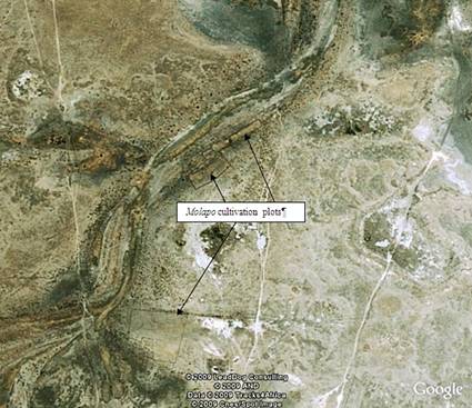
Areas designated for arable agriculture (locally known as Masimo). Arable areas are normally found or located in the periphery of the villages, but in some instances they are quite some distance (e.g. 20-50km) away. Although Mopipi is basically on the sandveld and largely unsuitable for arable agriculture, there are some pockets of suitable soils, especially along the flood plains and river channels. Residents have traditionally farmed the flood plains of the Boteti river which gets its water from the seasonal over-flows of the Okavango delta. Flood recession agriculture, locally known as molapo farming is practiced (Figure 6). This is a system where farmers take advantage of the moisture on the flood plains after the floods have receded. The system of farming has however been constrained by the drying up of the Boteti river channel.

Figure 6: Google map showing the main river channel and location of Molapo farming plots. (R. Sebego)
Cultivation is not only limited to molapo farming; fields are located upland on the sand plains and are dependent mostly on rainfall. This is the dryland farming technique.
The three major land use types (settlements, cattle posts and cultivation) are referred to as the tripartite system referring to the fact that different dwelling sites are kept by individual families in order to effectively optimize the different activities that are important for their livelihoods.
Veld products: these are wild growing resources that people have traditionally gathered for consumption, medicinal, and construction purposes. A variety of wild fruits and berries is edible and has been used as food supplements. Examples include Grewia flava, G. retinervis, Ximenia Americana, Vangueria infausta and mopane worm. A widely used medicinal plant of the dry Kalahari is the devil's claw (Harpagophytum. procumbens). Many other grass species are used as thatching grass e.g. Eragrostis pallens, Stipagrostis uniplumis, Hyparrhenia filipendula.