Soils

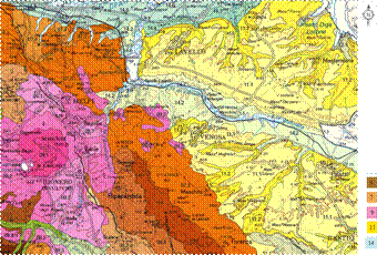
Soil map 1:250.000
E. A. C. Costantini, F. Urbano, G. L'Abate. SOIL REGIONS OF ITALY www.soilmaps.it Podis Basilicata http://basilicata.podis.it/ctr/ctr2.phtml

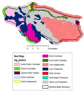
Soil map of Rendina Basin
| Soil province | landforms | geology | land use | Classification WRB '98 |
| 14.5 | alluvial plain, areas of recent evolution | sandy clayey sediments and silty sediments | arable lands, rotational crops, orchards |
[1]Petric Calcisols [2]Eutri-Fluvic Cambisols |
| 14.3 | complex mountainslopes slightly to moderately steep | alluvial and colluvial sediments, with clayey and sandy granulometry | arable lands, rotational crops, orchards | [1]Eutri-Vertic Cambisols |
| 14.4 | ancient terraced alluvial cone, slightly steep | sandy-clayey deposits | arable lands | [1]Calcic Luvisols |
| 11.2 | mountainslopes moderately to slightly steep | Monte Marano sands, Irsinia conglomerate (Pleistocene) | arable lands, vineyards, natural vegetation |
[1]Luvic Kastanozems [2]Eutric Cambisols |
| 11.1 | ancient Pleistocene surfaces, with flat summit surfaces slightly steep conglomerated Pleistocene deposits | Monte Marano Sands, Irsinia conglomerate (Pleistocene) | rotational arable land, olive-groves, irrigation crops, vineyards, uncommon natural vegetation |
[1]Luvi-Vertic Kastanozems [2]Luvic Kastanozems [3]Calcic Vertisols |
| 14.7 | alluvial floodplain of Ofanto river and Venosa torrent, almost flat | sandy and stony sediments | arable land, uncultivated land, uncommon riparian vegetation near the river |
[1]Eutri-Fluvic Cambisols [2]Calcaric Phaeozems [3]Calcari-Arenic Regosols |
| 14.2 | fluvio-lacustrine terrace with high incision of the Venosa torrent, numerous flat surfaces (fluvio-lacustrine flat) | fluvio lacustrine deposits, largely pyroclastic materials | arable land, permanent meadow, shrubby natural vegetation |
[1]Luvi-Vertic Phaeozems [2]Calcic Vertisols |
| 9.2 | long to moderately long mountainside of Vulture Mountain, sometimes slightly to moderately steep, prevailing exposition East to North-East | pyroclastic colluvial deposits | woodlands dominated by chestnut tree, pasture (strongly steep surfaces), meadows, arable land, olive-groves, vineyard |
[1] Luvic Phaeozems [2]Eutric Cambisols [3]Dystri-Andic Cambisols |
| 9.3 | flat surfaces with largely volcanic origin at footslope of Vulture Mountain, flat to slightly steep surfaces | pyroclastic colluvial deposits, as well fluvio-lacustrine deposists | arable land, permanent meadow, oliveyards, vineyards, shrubby natural vegetation (incisions of the drainage network) |
[1] Dystri-Andic Cambisols [2]Luvic Phaeozems [3Eutric Cambisols |
| 6.4 | undulated low hillslopes surfaces, mountainslopes with very variable slope | sandstones and marls | woodlands, meadows, arable land on moderately steep footslopes |
[1]Eutric Cambisols [2Eutric Cambisols |
| 6.3 | complex mountain slope, steep to moderately steep | quarzt-arenite with thin clayey layer | Woodlands, meadows and uncommon arable lands | [1]Eutric Cambisols |
| 7.3 | undulated hillslopes | clayey slate and marls (varicolored clays complex) | common arable lands, meadows and woodlands are present at high altitude |
[1]Luvi-Vertic Phaeozems [2]Calcaric Regosols |
Note: detailed soil information is available but partly deleted from this table in its final form