Physiographic setting of the plots
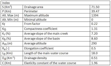
The Ribeira Seca Watershed is located on the Eastside of the Santiago Island, witha 71 km² of surface. The basin reflects the general morphology of Santiago, having very rough mountains. From the spring to the mouth of the creek, the following can be distinguished:
- The mountain massive of Pico da Antónia (1394m), the highest of the Island and oriented to the SE-NW direction. This formation dominates elongated hills and valleys with steep slopes and plane bottoms. On the occidental side (where the hotspot is located) the landscape is greener and much richer in species (fauna and flora). Nevertheless, on the side facing W or the oriental side, the ecosystems are extremely arid.
- The rocky scarps, authentic rocky barriers against the N-NE humid winds, form a siege in the W-SW part of the basin.
- The cliffy slopes of the Pico de Antónia and Órgãos formations are practically straight, with very steep slopes on top.
- The achadas (plateaus) of low and medium altitude, essentially in the downstream part of the basin present a relatively plane altimetry.
- The ditches of the main water courses, especially in the downstream areas, are encased and with wide bottoms, due to the fillings.

Table 1: Physiographical characterisation