Annual rainfall
Rainfall, amount and distribution, is the major factor affecting biomass production, and also soil erosion rates on hilly lands. Arid, semi-arid, and dry-sub humid climatic conditions are characterized by seasonal climate and specific ecological conditions, which make the existing ecosystems vulnerable to land degradation and desertification. The uneven annual and interannual distribution of rainfall and the occurrence of extreme events are the main climatic factors contributing to land degradation. The prevailing weather conditions during the growing period of plants may be so adverse that the soils remain bare, creating favorable conditions for overland flow and erosion. Studies conducted during the execution of MEDALUS projects have shown that soil erosion in hilly areas of the Mediterranean region with shrubby vegetation increases as annual rainfall decreases from 650 mm to 300 mm. The increase in soil erosion is attributed to the decreasing biomass production accompanied with lower vegetation cover. The trend during the last decades in the study sites of DESIRE is a decrease in the annual rainfall and an increase in the number of stormy events. Also, predictions using models show that a climate warming is accompanied by lower amounts of rainfall and higher rates of evapotranspiration. Under such conditions soil moisture content available for plant growth will decrease significantly, causing lower biomass production, decrease in soil organic matter content, deterioration of soil aggregate stability, decrease in soil infiltration rates, and increase in soil erosion rates and in desertification risk (Fig. 3). Furthermore, the transport and distribution of salts within a landscape and in a soil profile are affected by the prevailing water balance conditions, and the depth of the ground water. A general decrease in precipitation and/or an increase in evapotranspiration will cause an increase of the areas affected by soil salinization, especially of the lowlands around the Mediterranean region. Soil salinity problems will be most severe in areas receiving annual rainfall ranging from 300-600 mm.


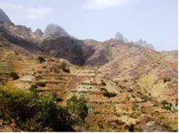
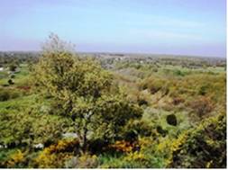
Fig. 3. Examples of areas receiving annual rainfall less than 300 mm (left, Cape Verde, Santiago islands) and greater than 750 mm (right, Peloponnesus, Greece)
Data for this indicator have been provided form the National and Local Meteorological Survives of the study sites and for meteorological stations located in or nearby to the study sites. The following classes of annual rainfall have been distinguished based on experimental data on soil erosion obtained from previous research and other pertinent research projects on desertification: (a) annual rainfall <280 mm, (b) annual rainfall 280-650 mm, (c) annual rainfall 650-1000 mm, and (d) annual rainfall >1000 mm.
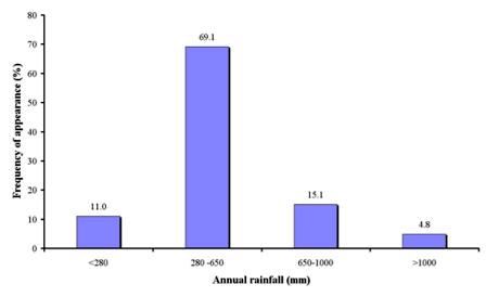
As Table 1 shows, data on annual rainfall were collected in 1582 field sites, corresponding to 17 study sites. The majority of the study field sites (69.1% of the total field sites) have an annual rainfall ranging between 280-650 mm (Fig. 4). Such field sides have been found in all cases of the study sites of Boteti Area-Botswana, Novij Saratov-Russia, Rendina Basin Basilicata-Italy, Nestos Basin Maggana-Greece, Guadalentin Basin Murcia-Spain, Eskisehir-Turkey, Konya Karapinar plain-Turkey, Loess Plateau- China, Mamora Sehoul-Morocco, and Crete-Greece, and in some cases in the study sites of Djanybek-Russia, Cape Verde-Santiago Island, and Crete-Greece. Therefore, such study field sites can be characterized as very sensitive to any climatic change and they are subjected to high vulnerability for land degradation and desertification. The next most important class of annual rainfall is the range of 650-100 mm, covering 15.1% of the study field sites, and corresponding in the study sites of Djanybek-Russia, Secano Interior-Chile, Mação-Portugal, Cointzio catchment-Mexico, and Crete-Greece. The driest field sites have been found in Zeuss-Koutine (Tunisia), in Santiago island (Cape Verde), and in Djanybek (Russia), covering 11.0% of the study sites. On the contrary, the wettest field sites are located in Gois-Portugal, and Cointzio catchment-Mexico study sites, covering 4.8% of the DESIRE field sites.
 **
**
Fig. 4. Distribution of average annual rainfall classes prevailing in the study field sites