Rainfall seasonality
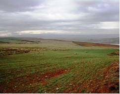
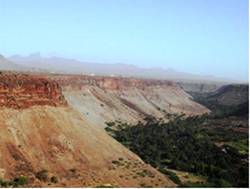
Rainfall seasonality is related to the distribution of rainfall during a normal year. An irregular distribution of rainfall means that most of the rainfall occurs in the period from October to May as in the Mediterranean areas. Rainfall seasonality affects soil erosion and vegetation composition and growth. Very high inter-annual rainfall variability causes periods of particularly long drought and sudden and high-intensity rainfall. Under hot and dry climatic conditions the tolerance to erosion of shallow soils in dry badlands with poor vegetation cover is rather low, and rain fed vegetation can no longer be supported, leading to desertification (Fig. 7). Reduced biomass production, in turn, directly affects the organic matter content of the soil and the aggregation and stability of the surface horizon against erosion. In addition reduced vegetation growth is followed by a net decrease of greenhouse gases assimilation by the plants and thus it may contribute to potential climate change at the local and regional scale and to desertification in a broad sense. However, at the same time the existing vegetation under arid and semi-arid climatic conditions exhibits a great capacity of adaptation and resistance to dry conditions, and many species can survive many months through prolonged droughts with soil moisture content below the theoretical wilting point protecting extensive areas from desertification.


Fig. 7. Typical examples of areas with rather seasonal precipitation and short drier season (Eskisehir Plain-Turkey, left) and extreme rainfall seasonality with most precipitation occurring in a period less than 3 months (Santiago Island-Cape Verde, right)
The rainfall seasonality for this project was estimated by the Seasonality Index (SI) (derived by Walsh and Lawler (1981). The following equation has been used for calculating the SI:

Where Ri is the total annual precipitation for the particular year under study and Xin is the actual monthly precipitation for month n. The season rainfall/total rainfall (%) index takes values from 0 to 100%. The statistical theoretic "normal" value for each season is 25%. The monthly rainfall/total rainfall (%) index has an equal distribution approximately 8% per each month. The bigger the difference from this value, the higher the rain seasonality. The precipitation regime then has been categorized using the classes of SIi delineated in the following Table.
| SIi | Precipitation regime |
| <0.19 | Precipitation spread throughout the year |
| 0.20-0.39 | Precipitation spread throughout the year, but with a definite wetter season |
| 0.40-0.59 | Rather seasonal with a short drier season |
| 0.60-0.79 | Seasonal |
| 0.80-0.99 | Marked seasonal with a long dry season |
| 1.00-1.19 | Most precipitation in <3 months |
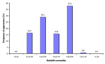
Data for this indicator were calculated for 1399 field sites, corresponding to 17 study sites (Table 1). Based on the existing data, the prevailing climatic conditions are characterized as marked seasonal with long dry season (Fig. 8), covering 37.9% of the study field sites, corresponding to the study sites of Crete-Greece, Djanybek-Russia, Novij Saratov-Russia, Santiago Island-Cape Verde, Konya Karapinar Plain-Turkey, Djanybek-Russia, Mação- Portugal, Mamora Sehoul-Morocco, and Secano Interior-Chile. The following important class of rainfall seasonality has a strong seasonal character with a short drier season measured, covering 29.1% of the study field sites, and particular in the study sites of Crete-Greece, Zeuss Koutine-Tunisia, Gois-Portugal, and Eskisehir Plain-Turkey. Climatic conditions with precipitation spread throughout the year but with a definite wetter season has been found in 16.4% of the study field sites and particularly in the areas of Guadalentin Basin-Spain, Djanybek-Russia, and Novij Saratov-Russia. Areas characterized as seasonal with respect to rainfall distribution have been defined in 15.8% of the study field sites of Boteti Area-Botswana, Nestos Basin Maggana-Greece, Cointzio catchment-Mexico, and the upper mountainous areas of Crete. Some of the study field sites in Santiago Island-Cape Verde have been characterized as the driest with most of the precipitation occurring in a period less than 3 months.

Fig. 8. Distribution of rainfall seasonality classes prevailing in the study field sites