Soil depth
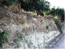
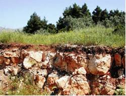
Soil depth can be considered as the most important soil indicator affecting desertification. Percentage vegetation cover of a soil surface under semi-arid climatic conditions is largely controlled by soil water storage capacity and therefore soil depth. Soil depth decrease due to soil erosion is a serious threat to the soil quality and productivity in hilly areas (Fig. 22). The effects of soil erosion on its productivity depend largely on the thickness and quality of the topsoil and on the nature of the subsoil. Most hilly soils are shallow or have some undesirable properties in the subsoil such as petrocalcic horizon, or bedrock (Fig. 22) that adversely affects yields. In either case, productivity will decrease as the topsoil gets thinner by erosion and undesirable subsoil is mixed into the topsoil by tillage.
Soil depth in the study field sites has been measured by using an auger or in existing cuts. The following classes have been distinguished: (a) very shallow, soil depth <15; (b) shallow, soil depth 15-30 cm; (c) slightly deep, soil depth 30-60 cm; (d) moderately deep, soil depth 60-100 cm; (e) deep, soil depth 100-150 cm; and (f) very deep, soil depth >150 cm.


Fig. 22. Deep soil formed on marl deposits (left) and shallow soil formed on limestone (right)
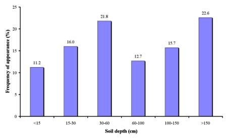
Soil depth has been measured in 1577 field sites, corresponding to 17 study sites (Table 3). The obtained results show a variety of soil depths depending on the type of parent material, slope gradient, and degree of erosion (Fig. 23). Many of the study fields have very deep soils (depth>150 cm), covering over 22.6% of the total sites. Such soils have been mainly found in Plateau-China and Nestos Basin Maggana-Greece and in some cases in the study sites of Crete-Greece, Santiago Island-Cape Verde, Eskisehir Plain-Turkey, Rendina Basin Basilicata-Italy, Cointzio catchment-Mexico, and Zeuss Koutine-Tunisia. The next most important class of soil depth is slightly deep (depth 30-60 cm), covering 21.8% of the field sites. Such soils have been found in all studies sites except Plateau-China, and Nestos Basin Maggana-Greece. Moderately deep (depth 60-100 cm) and deep soils (100-150 cm) cover 12.7% and 15.7% of the study field sites, respectively. Such soils have been described in all study sites except Plateau-China, and Nestos Basin Maggana-Greece. Very shallow (depth <15 cm) to shallow (15-30 cm) soils have been found in several cases covering 11.2% and 16.0%, respectively. Such areas are highly degraded very sensitive to desertification and they are found in the study sites of Konya Karapinar plain-Turkey, Boteti Area-Botswana, Zeuss Koutine-Tunisia, Crete-Greece, Santiago Island-Cape Verde, Eskisehir Plain-Turkey, Mação-Portugal, Mamora Sehoul-Morocco, Cointzio catchment-Mexico, Gois-Portugal, and Guadalentin Basin Murcia-Spain.

Fig. 23. Distribution of soil depth classes found in the study field sites