Exposure of rock outcrops
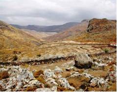
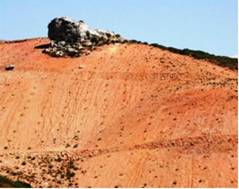
Exposure of rock outcrops refers to a mixed area that consists of spots of exposures of bedrock and soil. A type of land having little or no soil supported vegetation. Usually such areas have been greatly degraded due to soil erosion and they are mainly characterized as critical areas to desertification. Such conditions are very common in soils formed on consolidated parent materials such as limestone, sandstone, lava, etc. (Fig 27).


Fig. 27. Shallow highly degraded soils, with the bedrock exposed in patches on the soil surface (rock outcrops), formed on acid igneous rock (left) and limestone (right)
Rock outcrops have been defined for the purpose of the DESIRE project according to the percentage cover in four classes: (a) rock outcrops>60%, (b) rock outcrops = 30-60, (c) rock outcrops = 10-30%, (d) rock outcrops = 1-10%, and (e) none.
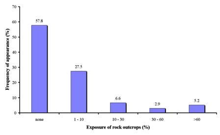
As Table 3 shows, data for rock outcrops have been defined in 1056 field sites, corresponding to 12 field sites. As Fig. 28 shows most of the field sites were free of rock outcrops covering 57.8% of the study field sites corresponding to all study sites. The following important class was this with rock outcrops exposed in an area of 1-10% of the study field, covering 27.5% of the study field sites. Such cases were found in all study sites except for Novij Saratov-Russia. The classes of rock outcrops 10-30%, 30-60%, and >60% were found in few cases in the study field sites (Fig. 28) of Boteti Area-Botswana, Santiago Island-Cape Verde, Mamora Sehoul-Morocco, Zeuss Koutine-Tunisia, Cointzio catchment-Mexico, Boteti Area-Botswana, and Guadalentin Basin Murcia-Spain.

Fig. 28. Distribution of rock outcrops classes measured in the various study field sites