Degree of soil erosion
The UNCCD has defined soil erosion as one of the main causes of land degradation and desertification. The erosion risk depends on several factors, such as slope gradient, vegetation cover, and soil type and rain erosivity. Soil erosion can be quantitatively estimated in experimental fields or by applying soil erosion models such as the PESERA model to be used in WB5 of this project. Furthermore, soil erosion can be qualitatively estimated by observing certain erosion features on the soil surface. A qualitatively measurement of soil erosion is the degree of erosion as it assessed in soil surveys. Soil erosion in this work package of the DESIRE project has been qualitatively determined by estimating the degree of soil erosion using the following soil surface characteristics: (i) the presence or not of the A-horizon, (ii) the existence and percentage of subsurface horizons, (iii) the degree of exposure of the parent material on the soil surface, and (iv) the presence of erosional gullies. Five classes of degree of erosion have been distinguished, very severe, severe, moderate, slight, and no erosion. The degree of soil erosion has been described using the following table.
| Erosion class | Description |
| No erosion | No erosion features are present in the soil surface |
| Slight | Parts of the A horizon have been eroded, so that usually less than 20% of the initial A horizon presents current scattered spots of erosion. |
| Moderate | Soils that present an intricate pattern of current subsurface horizons ranging on the average from 20% to 50% on the original A horizon. |
| Severe | Soils that shows an intricate pattern of subsurface horizons ranging from 50% to 80% of the original A horizon. In most areas of this class erosion, the parent material is exposed at the surface. |
| Very severe | Soils that have lost more than 80% of the A-horizon and some or all the deeper horizons throughout most of the area. Original soil can be identified only in spots. Some areas may be smooth, but most have an intricate pattern of gullies and the parent material is exposed at the soil surface. |
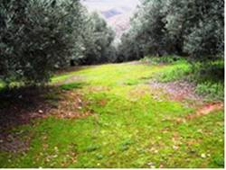
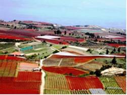
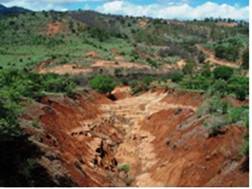
Some typical examples of soil surfaces with different degree of soil erosion are given in Fig. 30.


Fig. 30. Soil surfaces with slight (left), moderate (center) and very severe (right) degree of soil erosion
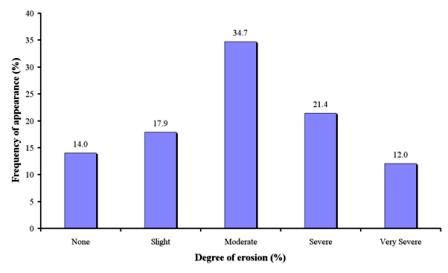
As Table 3 shows the degree of erosion has been described in 1221 field sites, corresponding to 16 study sites. As Fig 31 shows, the dominant class of degree of soil erosion is moderate erosion covering 34.7% of the study field sites. Such degree of soil erosion has been described in all study field sites of Konya Karapinar plain-Turkey and in some cases in all the rest study sites. The next important class is severe erosion covering 21.4% of the study field sites. Severe erosion has been described in all field sites of Novij Saratov-Russia, and in some cases in the rest of study sites except for Konya Karapinar plain-Turkey, and Djanybek-Russia. Very severe erosion has been found in 12.0% of the study field sites, corresponding to same cases for the study sites of Santiago Island-Cape Verde, Mamora Sehoul-Morocco, Zeuss Koutine-Tunisia, Cointzio catchment-Mexico, Guadalentin Basin, Loess Plateau-China, , Rendina Basin Basilicata-Italy, Murcia-Spain, and Crete-Greece. No to slight erosion have been estimated in 14.0% and 17.9% of the study field sites, respectively. Such degree of soil erosion has been defined mainly in plain areas in which the main process of desertification is soil salinization or in sloping forested areas fully covered with vegetation. No to slight erosion has been described in some of the field sites of the following study sites: Secano Interior-Chile, Boteti Area-Botswana, Santiago island-Cape Verde, Mamora Sehoul-Morocco, Gois-Portugal, Loess Plateau-China, Zeuss Koutine-Tunisia, Guadalentin Basin Murcia-Spain, Cointzio catchment-Mexico, Rendina Basin Basilicata-Italy, and Crete-Greece.

Fig. 31. Distribution of degree of soil erosion estimated in the study field sites