Vegetation cover type
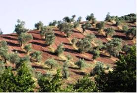
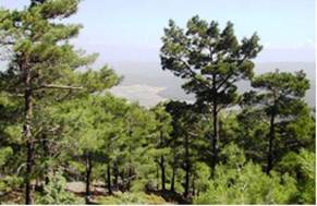
Vegetation cover type defines the specific characteristics of land uses such as vines, olives, cereals, pine forest, oak forest, etc (Fig. 35). Extensive Mediterranean areas cultivated with rainfed crops such as cereals, vines, almonds and olives are mainly confided to hilly lands with shallow soils very sensitive to erosion. These areas become vulnerable to erosion and desertification because of the decreased protection effect of the vegetation cover from raindrop impact during heavy rains. Soil erosion measurements conducted along the Mediterranean Europe and Portugal during the execution of MEDALUS projects have shown that under the existing land management practices vines generate the highest amount of runoff and sediment loss followed by eucalyptus, cereals, shrubland and olive groves in a decreasing rate. Olives present a particularly high adaptation and resistance to long term droughts and under semi-natural conditions support a remarkable diversity of flora and fauna even higher than some natural ecosystems, protecting hilly areas from erosion and desertification.


Fig 35. Examples of vegetation cover type corresponding to agriculture-olives (left) and forest-pines (right)
Land use types have been identified in the study field sites by: (a) simple field observations, and (b) aerial photographs or remote sensing images interpretation. The following categories of plant cover have been distinguished: (a) agricultural land uses: cereals, olives, vines, almonds, oranges, vegetables, cotton, bare land, etc.; and (b) forest areas: Mixed Mediterranean Machia/evergreen forest, Mediterranean machia, permanent grassland, annual grassland, deciduous forest, pine forest, and evergreen forest (except pines), etc.
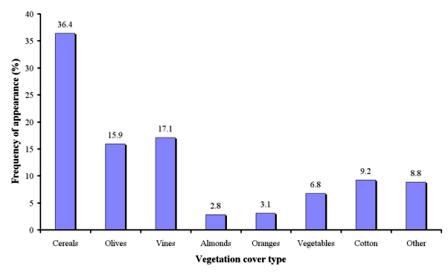
As Table 4 shows, vegetation cover type has been identified in 1108 field sites, corresponding to 15 study sites. The dominant agricultural land use identified in the study field sites was cereals, covering 36.4% of the total sites (Fig. 36). Such land use type has been mainly described in the study sites of Boteti Area-Botswana, Konya Karapinar plain-Turkey, Santiago island-Cape Verde, Mamora Sehoul-Morocco, Eskisehir-Turkey, Gois-Portugal, Cointzio catchment-Mexico, Zeuss Koutine-Tunisia, Guadalentin Basin Murcia-Spain, and Djanybek-Russia. Olive groves and vineyards have been found in about equal number of field sites (15.9%, 17.1%, respectively). Such land uses have been identified in all study sites except from Boteti Area-Botswana, Konya Karapinar plain-Turkey, Gois-Portugal, Santiago Island-Cape Verde, Novij Saratov-Russia, and Djanybek-Russia sites. Cotton has been described in 9.2% of the study field sites corresponding mainly to the study sites of Boteti Area-Botswana, Konya Karapinar plain-Turkey, Mamora Sehoul-Morocco, Eskisehir-Turkey, Guadalentin Basin Murcia-Spain, and Djanybek-Russia. Other land uses such as almonds, oranges, vegetables, etc. have been found in few cases, covering 2.8%, 3.1%, and 6.8% of the study field sites, respectively, corresponding mainly to the study sites of Secano Interior-Chile, Boteti Area-Botswana, Santiago Island-Cape Verde, Guadalentin Basin Murcia-Spain, Novij Saratov-Russia, and Crete-Greece.

Fig. 36. Distribution of land use types identified in agricultural areas of the study sites