Vegetation cover
The percentage of soil which is covered by green vegetation is defined as plant cover. Leaf area index (LAI) is an alternative expression of the term plant cover which gives the area of leaves in m² corresponding to an area of one m² of ground. Many studies have demonstrated that in a wide range of environments, both runoff and sediment loss decrease exponentially with increasing percentage of plant cover. Forest vegetation reduces significantly summer soil surface temperatures and it is necessary for the regeneration of many forest species in the Mediterranean. A vegetation cover 45-50% is considered as critical value since above this value soils are adequately protected from raindrop impact and soil erosion is significantly reduced.
Vegetation cover has been measured in the field by assessing the percentage of the ground that it is covered by the existing annual or perennial vegetation. Aerial photographs or satellite images has been also used for measuring vegetation cover of extensive areas. Four classes of vegetation cover have been used for the purpose of this project: (a) vegetation cover <10%, (b) vegetation cover =10-25%, (c) vegetation cover = 25-50%, (d) vegetation cover = 50-75%, and (e) vegetation cover >75%.
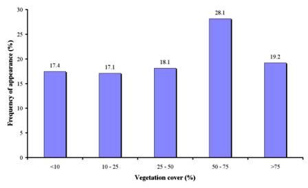
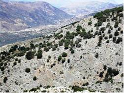
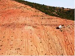
Vegetation cover has been measured in 1141 field sites, corresponding to 15 study sites (Table 4). As Fig. 37 shows, field sites with vegetation cover classes greater than the critical value of 50% were found in 28.1% (cover 50-75%) and in 19.2% (cover >75%) of the study field sites (Fig. 37). Such well vegetated field sites correspond mainly to the study sites of Secano Interior-Chile, Boteti Area-Botswana, Santiago island-Cape Verde, Gois-Portugal, Mamora Sehoul-Morocco, Cointzio Catchment-Mexico, Eskisehir-Turkey, Zeuss Koutine-Tunisia, Guadalentin Basin Murcia-Spain, Novij Saratov-Russia, Djanybek-Russia, Crete-Greece, and Mação-Portugal. Vegetation cover classes <10%, 10-25%, and 25-50%, which are less than the critical value of 50%, have been measured in a significant number of field sites, covering 17.4%, 17.1%, and 118.1% of the total sites (Fig. 37). Such poorly vegetated sites have been found in all study sites except for Eskisehir-Turkey site. Field sites almost bare (vegetation cover <10%) have been mainly described in the study sites of Secano Interior-Chile, Boteti Area-Botswana, Santiago island-Cape Verde, Gois-Portugal, Cointzio Catchment-Mexico, Mamora Sehoul-Morocco, Zeuss Koutine-Tunisia, Guadalentin Basin Murcia-Spain, Crete-Greece, and Zeuss Koutine-Tunisia. Most of these field sites have so much eroded that the consolidated rock has been exposed on the soil surface generating probably high water runoff rates but low soil loss since there is no soil left to be eroded (Fig. 38). Of course there cases in which vegetation has been cleared for installing a new plantation creating very adverse conditions for soil erosion, land degradation and desertification (Fig. 38).

Fig. 37. Distribution of vegetation cover classes identified in the study field sites


Fig. 38. Areas with poor vegetation cover (<10%) in which soil erosion rates are low since bedrock has been exposed (left) or very high since vegetation has been cleared for new plantation exposing the soil to the raindrop impact (right)