Deforested area
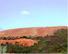
Large scale deforestation of semiarid and dry sub-humid areas accompanied by intensive cultivation and overgrazing resulted in accelerated erosion and the formation of badlands with very shallow soils (Fig. 39a). Such areas are very sensitive to land degradation and desertification. Deforested area represents an important indicator for addressing political measures for protecting natural vegetation and combating desertification. It is defined as the total deforested surface annually expressed as a percentage of the total land surface. Such data are available for forested areas for different periods and territory levels from different organizations such as FAO, EUROSTAT, ISTAT, CFS, etc. This indicator is measured by using a combination of satellite-based earth observation and intensive field data collection to estimate deforestation process on a certain territory. Such data have been provided mainly from the national forestry departments.


Fig. 39a. Examples of deforested area to be used for pasture (left) and planting vines (right)
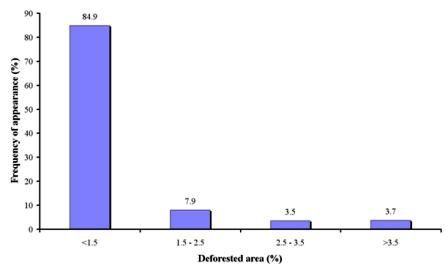
The following four classes of deforestation have been used: (a) low, <1.5 % of total deforested surface/total territorial surface/per year; (b) moderate, 1.5-2.5 % of total deforested surface/total territorial surface/per year; (c) high, 2.5-3.5 % of total deforested surface/total territorial surface/ per year; (d) very high, >3.5 % of total deforested surface/total territorial surface/ per year.
As Table 4 shows, data for deforested areas have been collected in 403 field sites, corresponding to 9 study sites. As Fig. 39b shows, the dominant class of deforestation is low for the study field sites covering 84.9% of the total sites. Low deforested rate has been measured in all field sites of Konya Karapinar plain-Turkey, Novij Saratov-Russia, Djanybek-Russia, and in most of the cases in Mação-Portugal, and Boteti Area-Botswana study sites. Moderate to high rate of deforestation have been identified in few field sites in Mação-Portugal, and Boteti Area-Botswana.

Fig. 39. Distribution of deforested area classes expressed as a percentage of land deforested over the total land forested surface per year