| Using the Desertification Risk Assessment Tool |
 |
|
Source: extracted from Karavitis, C., Kosmas, C. et al (submitted article) An expert system towards assessing desertification risk using indicators. Environmental Management
The methodology for defining land degradation and Desertification Risk Index (DRI) that is used by the Desertification Risk Assessment Tool was initially assessed using independent data on erosion and organic matter content of the soil, that were collected in the study sites of Greece. Since the collected data for the various indicators were drawn only from one country (Greece) they offer no significant variations especially in the indicators related to socio-economic characteristics.
The DESIRE methodology was developed using data from a wide range of physical environment and socio-economic characteristics from all over the world. However, the indicator data collected could not be used for the application phase, since they were already used for the DRI development. Thus, in order to avoid autocorrelation, independent data had to be used.
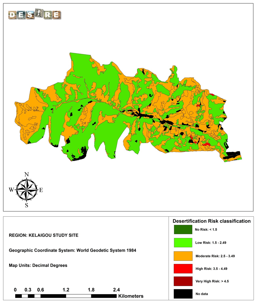
Therefore, the DRI calculation was performed using independent data produced by indicator values estimated for each case study area, based on the WOCAT QM database also developed in the DESIRE project (see »WOCAT tool for mapping land degradation and land conservation). The following study sites representing different desertification processes were chosen for this purpose: Sehoul Morocco (water erosion), Eskisehir Turkey (water erosion), Dzhanibek Russia (Overgrazing, Salinization, water stress), Kelaigou China (tillage practices resulting in increased water erosion) and Mação Portugal (forest fires, water erosion).
From the land use system, land degradation and sustainable land management information described in the database for each map unit, the pertinent data was translated into indicators values following the assigned indicator categories and weights according to the risk assessment method. Then, the indicator values were inserted in the Desertification Risk Assessment Tool. Overall, 1119 indicators in 83 map units in the five case study areas were assigned, whose values were calculated. Following this procedure the DRI was estimated for every map unit. In the case that there were more than one degradation processes per map unit, then the dominant process was used as it was described in the WOCAT QM database. Finally, the DRI values for each map unit were depicted in a color scale and the results were visualized in the corresponding maps.
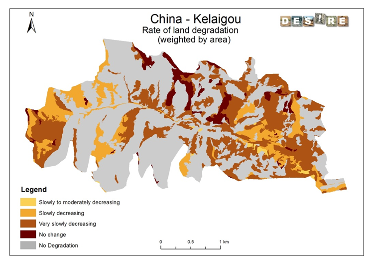
The Assessment Tool was also applied to all the other DESIRE study sites, although the results are not included in the HIS. Overall, the application of the Desertification Risk Assessment Tool has produced output that generally correlates with the WOCAT approach. The indicator values derived from the WOCAT QM database have given results that were very similar to those of the WOCAT maps. Although the same database was used in both approaches, the methods that were applied were quite different. The DRI approach was developed based on the collected datasets under specific protocols and uses indices to estimate desertification risk, while the WOCAT QM method provides maps of degradation status (including existing trends) based on protocols of expert assessment. Despite of such differences in the approaches, the resulting maps were comparable. This demonstrates the complementarity of both approaches, as well as their distinctiveness in usage. Furthermore, the Desertification Risk Assessment Tool seems robust enough to provide reasonable approximations not only when quantitative datasets (such as the indicator database) are available, but also when such data are not in abundance and estimates and translations from existing data sets have to be used to provide the necessary input. Since the creation of a full quantitative dataset of indicators is a labour-intensive task, it is an advantage that the method may also be used with less elaborate databases. This facilitates the application of Assessment Tool in other areas, and thus allows land use managers around the world to initially estimate what the effect of using different management options might be on desertification risk.
Conclusions
The DESIRE indicator based methodology for an expert system development was achieved using data from a wide range of physical environment and socio-economic situations, at a world-wide scale. The application results obtained have shown that indicators may be used in assessing land degradation and desertification risk for a wide range of physical environmental, social and economic conditions in the study sites. The application in areas beyond the Mediterranean region may constitute an innovation per se. Additionally, the use of two different data bases worldwide contributes also to the originality of the approach. In order to apply the methodology, it is important to have data for all the indicators assigned for each process or cause of land degradation. However, should the data be incomplete, existing similar data may be translated into indicators and then used.
The comparative analysis has shown that indicators may be used worldwide for assessing desertification risk. The methodology developed here may be used to assess the efficiency and efficacy of different land management practices and degradation monitoring techniques for combating desertification at farm level and, given the required information, at regional level, in a variety of locales. The system of indicators may enable land users to test different scenarios for ecosystem vulnerability in order to assess critical stress factors and their impacts on desertification. In this regard, the assessment tool may allow decision-makers worldwide to generate appropriate and timely desertification measures by estimating how the desertification risk changes through the application of certain applied responses. It may also provide a standard for assessing the effectiveness of the various land management practices. For such an assessment, the desertification risk assessment method has the following advantages:
Finally, around the world successful development of expert (and similar decision support) systems and application of desertification mitigation and general natural resources management calls for flexible adaptive institutions of a scale and character that will enable them to be utilized effectively in a fast changing, evolving and complex socio-economic environment. The results of this work should be imbedded in a policy options framework incorporating a structural participatory process involving stakeholders, experts, end users and decision makers.
|
|||||||||||
Acknowledgement
The DESIRE project was
|
DESIRE brought together the expertise of
26 international research institutes
and non-governmental organisations.
This website does not necessarily
represent the opinion of the
European Commission. The European
Commission is not responsible for
any use that might be made of the
information contained herein.