|
Evaluating the desertification risk assessment tool with local experimental results |
 |
|
Author: Victor Jetten
Introduction
The coastal region of the East Nestos River Delta (Maggana, northern Greece) has limited freshwater supplies although irrigation is exceptionally intensive. Studies show that there is intrusion of seawater into the coastal aquifer. The shallow brackish groundwater is in use for irrigation since the last 40-50 years, which has caused severe salinization of the soil. Apart from the chemical problems for crop growth, salinization affects the permeability of soil and causes infiltration problems, because sodium in the groundwater replaces calcium and magnesium adsorbed on the soil clays and causes dispersion of soil particles: a breakdown of aggregates and natural soils structure. Also deeper in the soil this has caused compacted layers to form. Salinization is very difficult to reverse, and the only possible solution in the area lies in flushing the soil with fresh water from the river systems or fresh groundwater further inland. This experiment tests the soil degradation can be reversed on a field scale and if this results in better crop performance.
Desertification indices
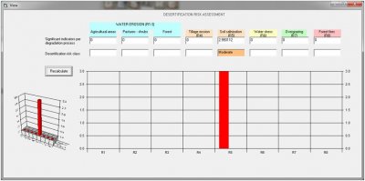
The desertification indicator in this area is salinization. None of the others apply. When filling in the area characteristics the salinization aspect turns out to be moderate/high (2.99). This is mainly due to the factor “exploitation of the groundwater”. When this is high (over-exploitation) the salinization risk is medium to high, when there is no exploitation this is lowers the risk to “no risk”. This factor and the factor “population density” seem to be the only ones correlated to salinization risk in the system. This means that the technology (fresh water irrigation) gives a lowering of the salinization risk because the assumption is that this will decrease groundwater exploitation and even groundwater recharge (risk index = 0.75).
 |
Cereals/vegetables salinization risk with groundwater exploitation (unmitigated circumstances) |
Conclusions
The indicator tool correctly identifies the area as having a high salinization risk but this depends only on one factor: groundwater exploitation. Thus different technologies that influence this factor will have an immediate effect, others (such as applying chemicals) will not have an effect.
|


