Introduction and objectives
Rationale
Sustainable management of the natural resource base is one of the truly fundamental issues that the international community will have to address effectively over the next two decades. The last twenty years have seen an emphasis on global and national economic management; the next twenty will need to address environmental management effectively.
This needs to follow a globally structured approach, based on adequate, reliable, up-to-date data and knowledge, and governed by appropriate international strategies and agreements. One key product sorely lacking to reach this goal is an overview of where land degradation takes place at what intensity and how land users are addressing this problem through sustainable land management.
In order to fill this knowledge gap, three projects have collaborated closely to establish a standardised and generally applicable mapping method: DESIRE, WOCAT and LADA.
Within the context of WP1.2, the spatial extent of degradation as well as the extent of measures to combat this degradation in the DESIRE study sites have been studied. This has resulted in both descriptions of the study sites, and in maps. These maps show the degree of degradation, but they also show areas where protection and restoration measures have been applied and with what degree of success. This assessment enables putting the study sites in a broader environmental and socio-economic context.
Defining degradation
Land degradation has been defined LADA (the Land Degradation Assessment in Drylands project, which is implemented by FAO with funding from GEF, develops tools and methods to assess land degradation in dryland ecosystems, at a range of spatial and temporal scales. It also builds the national, regional and international capacity for making interventions to mitigate land degradation and promote sustainable land use.) as the reduction in the capacity of the land to provide ecosystem goods and services (G&S) and assure its functions over a period of time for its beneficiaries.
Ecosystem goods represent the material products that are obtained from natural systems for human use (DeGroot et al. 2002). Ecosystems goods are generally tangible, material products that result from ecosystem processes, such as food, forage, timber, biomass fuels, and many pharmaceuticals.
Ecosystem services are the conditions and processes through which natural ecosystems sustain and contribute to allow humans to meet their (tangible and intangible) needs. Ecosystem services are the actual life-support functions, such as cleansing, recycling, and renewal, and they confer many intangible aesthetic and cultural benefits as well (Daily, 1997).
None of these G&S is easily defined. In order to use this scheme for assessment of degradation, these services should first be transferred into tangible, measurable entities because terms such as "regulating climate" are not readily measured or estimated as such. Biodiversity, being at the basis of most biological processes, is inherently linked to the ecosystem services, but the relationship may be difficult to quantify. Cultural and aesthetical services are more often considered as attributes of "landscapes" than of the ecosystems and the value attached to them can be not proportional to the ecosystem health.
To be able to measure and map the effects of land degradation on G&S, it would be useful to link these to quantifiable "resources", or "assets". A similar idea was introduced by the Ekins (1992) and, later, by Serageldin and Steer (1994) of the World Bank, by means of the "Capitals" framework: the state of the resources as a whole was reported in terms of its level of manufactured, human, social and natural capitals. By measuring or estimating all capitals available at different periods in time it should be possible to quantify the change due to land degradation according to a multi-dimensional perception.
According to the approach being developed by LADA, six key assets are defined in a way that makes it easier to relate them to G&S, thus providing a more consistent basis to quantify their relevance in relation to land degradation assessment. The six assets are listed below:
- Social and cultural benefits;
- Biodiversity;
- Soil health;
- Water quality and quantity;
- Opportunity value;
- Biomass: accumulated (standing and below-ground biomass) and biomass yearly increment;

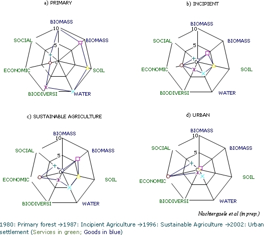
Figure 1: Effects of land use changes on ecosystem goods and services: forest cutting and introduction of agricultural activities. a) 1980: Primary forest. b) 1987: Incipient Agriculture. c) 1996: Sustainable Agriculture (improvements implemented) d) 2002: Urban settlement (transformed into building land).
Each change in land use will affect one or more of these assets negatively or positively. It is the total picture of negative and positive impacts that determines the perceived seriousness of degradation and this is again depending of priorities: urbanization clearly has a negative impact on total biomass or biodiversity but it has a positive impact - in most cases - on the social and economic assets.
Objectives
The objectives of WP 1.2 was to collect Study Site Descriptions provided by all Study Sites and to complement these with a spatial overview (mapping) of the occurrence of degradation and of the measures to prevent or mitigate this degradation.
The ultimate goal of the mapping exercise is to obtain a picture of the distribution and characteristics of land degradation and conservation / SLM activities for the different study sites. The final output can be generated on-line in the form of maps of land degradation status, causes and impacts, and conversely the conservation status and impacts for specific land use systems in the area.