Climate, geology and geomorphology
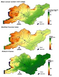
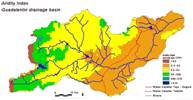
The climate in the Guadalentín varies from semi-arid to sub-humid Mediterranean (see Figure 4 - 6), with mean annual precipitation between less than 300 to more than 500 mm, and an average annual temperature between 12 and 18°C. Precipitation shows an inter-annual coefficient of variation between 0.2 and 0.5, though high inter-seasonal variation is also present. Droughts, centred in the summer, commonly last for more than 4-5 months. Annual potential evapotranspiration rates larger than 1000mm are common in large parts of the basin (Figure 5). With an aridity index (UNESCO, 1979) dominantly between 0.2 and 0.5, the main part of the basin is considered to be semi-arid (Figure 6).
Geologically the Guadalentín basin lies on the eastern edge of the Betic ranges, whose SW-NE axis and faults have determined the main structure of the drainage network. The geomorphology of the area is dominated by strongly folded and faulted (Eocene and Oligocene) limestone hills with footslopes developed in Eocene Marls. The Guadalentín is an ephemeral river for the major part of its course. The upper section of the basin has a rather dense drainage density in the headwater areas of Sierra de Maria (max 2045 m.a.s.l.), Sierra del Gigante (1554 m), Sierra Espuña (1585m), all on Cretaceous and Jurassic limestones and dolomites, and Sierra de las Estancias (1467 m) on Paleozoic shales and phyllites. In the central part of the basin several meseta-like plains at altitudes of ca. 1000 m can be found. The middle section is characterised by an undulating landscape with long pediments and incised river terraces. The lower reach is characterised by a nearly flat valley bottom with series of well developed alluvial fans at the base of the sierras.


